HisobotOchiq kirish
Amudaryo havzasining neft-gaz geologiyasi va resurslari (Turkmaniston, O‘zbekiston, Afg‘oniston va Eron)
Petroleum Geology and Resources of the Amu-Darya Basin, Turkmenistan, Uzbekistan, Afghanistan, and Iran
https://doi.org/10.3133/b2201H
Asosiy jihatlar
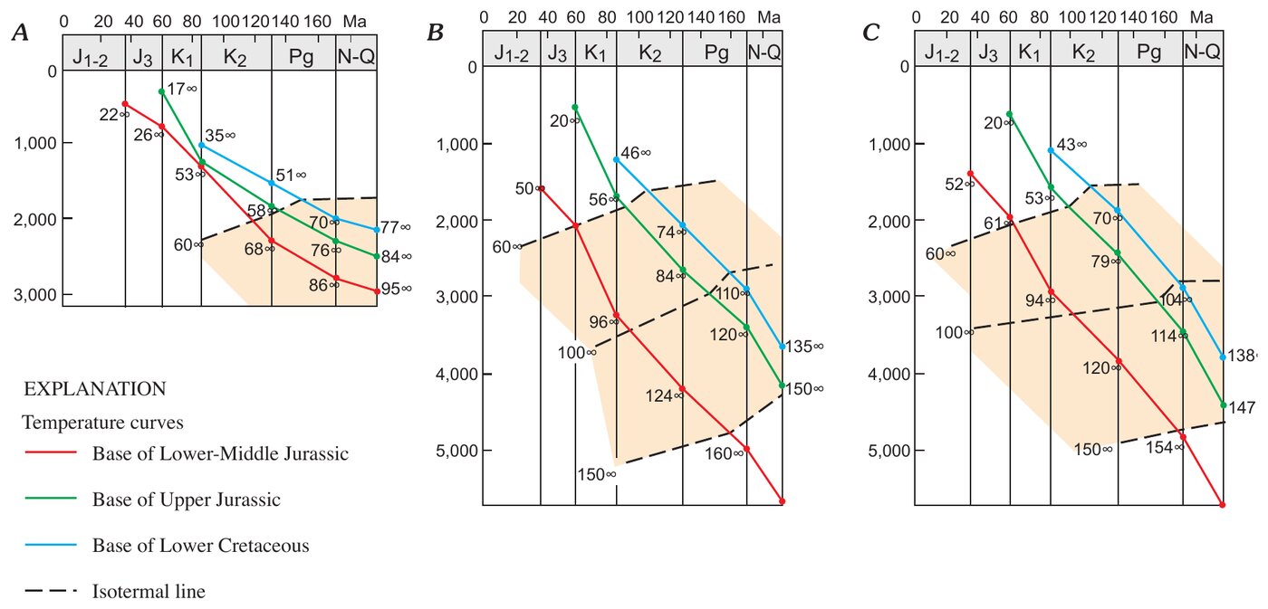
- Hozirgi geotermik gradient: ko‘p hududlarda har 100 m ga 3,0–3,5 °C (Ovodov va Pechernikov, 1987).
- Havzaning katta qismida yuqori yura karbonatlarining ustki chegarasi 3 000–5 000 m chuqurlikda. Rif karbonatlari: g‘ovaklik 14–19%, o‘tkazuvchanlik 25–400 mD, kollektor qatlamlar qalinligi 200 m gacha; botiq markazidagi kollektor qatlamlar: 5,5–11% va 0,2–10 mD.
- Shatlik qatlami qumtoshlari asosan 3–3,5 km chuqurlikda yotadi, qalinligi 120–130 m gacha: sochiluvchan qumtoshlarda g‘ovaklik 25–33%, o‘tkazuvchanlik odatda 1 000 mD dan yuqori.
- Xiva–Zaunguz botig‘ining shimolidagi quyi–o‘rta yura qumtoshlari, taxminan 2 km chuqurlikda: g‘ovaklik 17,4% gacha, o‘tkazuvchanlik 40 mD gacha; 2,5–3 km da g‘ovaklik odatda 10% dan past.
- Buxoro pog‘onasidagi Gazli koni: yuqori bo‘r jinslarida 50–1 200 m chuqurlikda 10 ta mahsuldor qatlam; qumtoshlar g‘ovakligi 13–23%, o‘tkazuvchanligi yuzlab millidarsi.
- Davlatobod koni: yuqori yura jinslari bilan tutashgan zonada Shatlik kollektoridagi bosim gidrostatik bosimdan 1,3 baravar yuqori, shimoliy va shimoli-g‘arbiy gaz-suv chegarasida esa deyarli gidrostatik. Gaz-suv chegarasidan sharqda Shatlik qatlami suvida erigan vodorod sulfid aniqlangan.
Annotatsiya
The Amu-Darya basin is a highly productive petroleum province in Turkmenistan and Uzbekistan (former Soviet Union), extending southwestward into Iran and southeastward into Afghanistan. The basin underlies deserts and semideserts north of the high ridges of the Kopet-Dag and Bande-Turkestan Mountains. On the northwest, the basin boundary crosses the crest of the Karakum regional structural high, and on the north the basin is bounded by the shallow basement of the Kyzylkum high. On the east, the Amu-Darya basin is separated by the buried southeast spur of the Gissar Range from the Afghan-Tajik basin, which is deformed into a series of north-south-trending synclinoria and anticlinoria. The separation of the two basins occurred during the Neogene Alpine orogeny; earlier, they were parts of a single sedimentary province. The basement of the Amu-Darya basin is a Hercynian accreted terrane composed of deformed and commonly metamorphosed Paleozoic rocks. These rocks are overlain by rift grabens filled with Upper Permian-Triassic rocks that are strongly compacted and diagenetically altered. This taphrogenic sequence, also considered to be a part of the economic basement, is overlain by thick Lower to Middle Jurassic, largely continental, coal-bearing rocks. The overlying Callovian-Oxfordian rocks are primarily carbonates. A deep-water basin surrounded by shallow shelves with reefs along their margins was formed during this time and reached its maximum topographic expression in the late Oxfordian. In Kimmeridgian-Tithonian time, the basin was filled with thick evaporites of the Gaurdak Formation. The Cretaceous-Paleogene sequence is composed chiefly of marine clastic rocks with carbonate intervals prominent in the Valanginian, Barremian, Maastrichtian, and Paleocene stratigraphic units. In Neogene time, the Alpine orogeny on the basin periphery resulted in deposition of continental clastics, initiation of new and rejuvenation of old faults, and formation of most structural traps. A single total petroleum system is identified in the Amu-Darya basin. The system is primarily gas prone. Discovered gas reserves are listed by Petroconsultants (1996) at about 230 trillion cubic feet, but recent discoveries and recent reserve estimates in older fields should increase this number by 40 to 50 trillion cubic feet. Reserves of liquid hydrocarbons (oil and condensate) are comparatively small, less than 2 billion barrels. Most of the gas reserves are concentrated in two stratigraphic intervals, Upper Jurassic carbonates and Neocomian clastics, each of which contains about one-half of the reserves. Reserves of other stratigraphic units—from Middle Jurassic to Paleogene in age—are relatively small. Source rocks for the gas are the Lower to Middle Jurassic clastics and coal and Oxfordian basinal black shales in the east-central part of the basin. The latter is probably responsible for the oil legs and much of the condensate in gas pools. Throughout most of the basin both source-rock units are presently in the gas-window zone. Traps are structural, paleogeomorphic, and stratigraphic, as well as a combination of these types. The giant Dauletabad field is in a combination trap with an essential hydrodynamic component. Four assessment units were identified in the total petroleum system. One unit in the northeastern, northern, and northwestern marginal areas of the basin and another in the southern marginal area are characterized by wide vertical distribution of hydrocarbon pools in Middle Jurassic to Paleocene rocks and the absence of the salt of the Gaurdak Formation. The other two assessment units are stratigraphically stacked; they occupy the central area of the basin and are separated by the regional undeformed salt seal of the Gaurdak Formation. The largest part of undiscovered hydrocarbon resources of the Amu-Darya basin is expected in older of these assessment units. The mean value of total assessed resources of the Amu-Darya basin is estimated at 164 trillion cubic feet of gas and about 4 billion barrels of petroleum liquids, most of which is condensate.
Ingliz tilidagi annotatsiya hisobotdan olingan. Mualliflar annotatsiyasi Public domain (USGS) litsenziyasi asosida keltirilgan. Annotatsiya ingliz tilida berilgan.
Sodda qilib aytganda
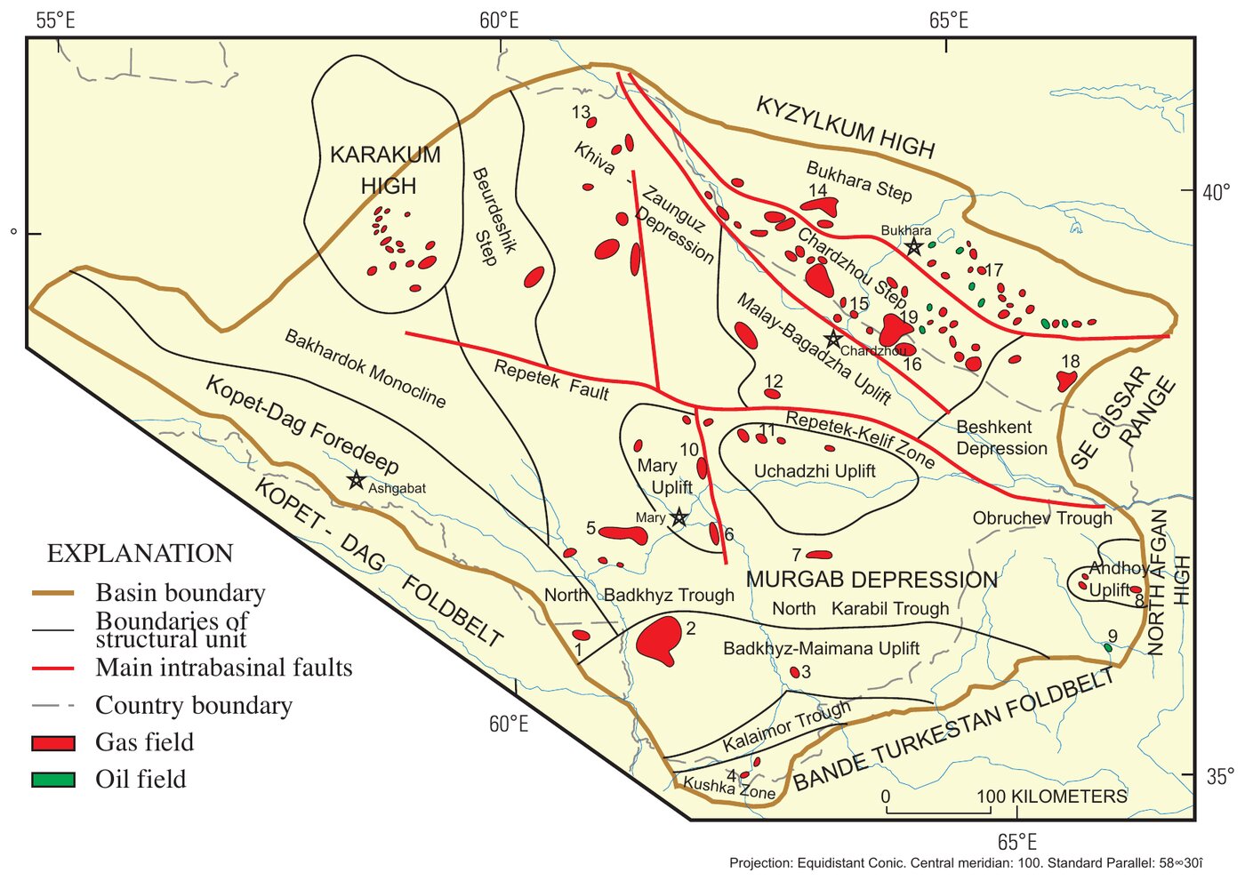
AQSh Geologiya xizmatining (USGS) bu hisobotida Amudaryo havzasining neft-gaz geologiyasi baholangan. Havza Turkmaniston va O‘zbekistondagi yirik gaz provinsiyasi bo‘lib, Afg‘oniston va Eronga ham cho‘ziladi. Uning shimoli-sharqiy qismiga Buxoro va Chorjo‘y pog‘onalari kiradi: bu yerda uzilmalar bilan chegaralangan poydevor bloklari Qizilqum ko‘tarilmasidan havza tomon pog‘ona-pog‘ona tushadi. Shu qismda Beshkent botig‘i ham bor, unda yura yotqiziqlarining tagi 5 km dan chuqurda yotadi. O‘zbekistonning yuqori yura karbonatlaridagi gaz, kondensat va neft zaxiralarining asosiy qismi shu ikki pog‘onada joylashgan.
Paleozoy poydevori va perm–trias rift grabenlari ustida qalin quyi–o‘rta yura ko‘mirli jinslari, riflar bilan kellovey–oksford karbonatlari, Gaurdak svitasining qalin kimerij–titon tuzlari hamda bo‘r–paleogen dengiz bo‘lakli jinslari yotadi. Hozirgi geotermik gradient nisbatan yuqori: ko‘p hududlarda har 100 m ga 3,0–3,5 °C. Shu sababli chuqurlikdagi quyi–o‘rta yura jinslarida qatlam harorati baland. Yura yotqiziqlarining tagi Ko‘petdog‘ oldi bukilmasi va Murg‘ob botig‘ida 6–8 km, Xiva–Zaunguz botig‘ida esa 4–5 km chuqurlikda.
Asosiy kollektorlar — yuqori yura karbonatlari va goteriv yarusidagi Shatlik qatlami qumtoshlari. Eng yaxshi xossalar rif ohaktoshlarida; karbonatlarning g‘ovakligi chuqurlikka bog‘liq emas, quyi–o‘rta yura qumtoshlari esa chuqurlashgan sari g‘ovakligini tez yo‘qotadi. Murg‘ob botig‘i va unga yondosh strukturalarda Gaurdak tuzlari ostidagi qatlam bosimlari anomal yuqori, tuzlar ustida esa gidrostatik.
Rasmlar (2)
Iqtibos namunasi
G. F. Ulmishek (2004). Petroleum Geology and Resources of the Amu-Darya Basin, Turkmenistan, Uzbekistan, Afghanistan, and Iran. U.S. Geological Survey Bulletin 2201-H, version 1.0. https://doi.org/10.3133/b2201H