ReportOpen access
Petroleum Geology and Resources of the Amu-Darya Basin, Turkmenistan, Uzbekistan, Afghanistan, and Iran
https://doi.org/10.3133/b2201H
Highlights
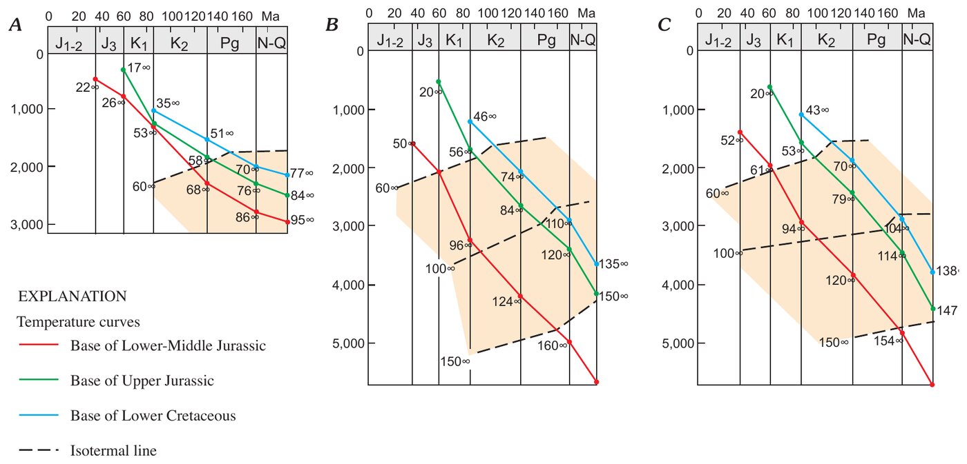
- Present-day geothermal gradient: 3.0–3.5 °C per 100 m in most areas (Ovodov and Pechernikov, 1987).
- Top of the Upper Jurassic carbonates at 3,000–5,000 m over most of the basin. Reef carbonates: porosity 14–19%, permeability 25–400 mD, reservoir rocks up to 200 m thick; basinal reservoir beds: 5.5–11% and 0.2–10 mD.
- Shatlyk Bed sandstones, at 3–3.5 km over most of their area and up to 120–130 m thick: porosity 25–33% in friable sandstones, permeability commonly above 1,000 mD.
- Lower–Middle Jurassic sandstones in the northern Khiva-Zaunguz depression, at about 2 km: porosity up to 17.4%, permeability up to 40 mD; at 2.5–3 km, porosity commonly below 10%.
- Gazli field on the Bukhara step: 10 pay zones in Upper Cretaceous rocks at 50–1,200 m, with sandstone porosity of 13–23% and permeability in the hundreds of millidarcies.
- Dauletabad field: Shatlyk reservoir pressure 1.3 times hydrostatic where it connects with Upper Jurassic rocks, near hydrostatic at the northern and north-western gas-water contact. Hydrogen sulfide dissolved in water has been found in the Shatlyk Bed east of the gas-water contact.
Abstract
The Amu-Darya basin is a highly productive petroleum province in Turkmenistan and Uzbekistan (former Soviet Union), extending southwestward into Iran and southeastward into Afghanistan. The basin underlies deserts and semideserts north of the high ridges of the Kopet-Dag and Bande-Turkestan Mountains. On the northwest, the basin boundary crosses the crest of the Karakum regional structural high, and on the north the basin is bounded by the shallow basement of the Kyzylkum high. On the east, the Amu-Darya basin is separated by the buried southeast spur of the Gissar Range from the Afghan-Tajik basin, which is deformed into a series of north-south-trending synclinoria and anticlinoria. The separation of the two basins occurred during the Neogene Alpine orogeny; earlier, they were parts of a single sedimentary province. The basement of the Amu-Darya basin is a Hercynian accreted terrane composed of deformed and commonly metamorphosed Paleozoic rocks. These rocks are overlain by rift grabens filled with Upper Permian-Triassic rocks that are strongly compacted and diagenetically altered. This taphrogenic sequence, also considered to be a part of the economic basement, is overlain by thick Lower to Middle Jurassic, largely continental, coal-bearing rocks. The overlying Callovian-Oxfordian rocks are primarily carbonates. A deep-water basin surrounded by shallow shelves with reefs along their margins was formed during this time and reached its maximum topographic expression in the late Oxfordian. In Kimmeridgian-Tithonian time, the basin was filled with thick evaporites of the Gaurdak Formation. The Cretaceous-Paleogene sequence is composed chiefly of marine clastic rocks with carbonate intervals prominent in the Valanginian, Barremian, Maastrichtian, and Paleocene stratigraphic units. In Neogene time, the Alpine orogeny on the basin periphery resulted in deposition of continental clastics, initiation of new and rejuvenation of old faults, and formation of most structural traps. A single total petroleum system is identified in the Amu-Darya basin. The system is primarily gas prone. Discovered gas reserves are listed by Petroconsultants (1996) at about 230 trillion cubic feet, but recent discoveries and recent reserve estimates in older fields should increase this number by 40 to 50 trillion cubic feet. Reserves of liquid hydrocarbons (oil and condensate) are comparatively small, less than 2 billion barrels. Most of the gas reserves are concentrated in two stratigraphic intervals, Upper Jurassic carbonates and Neocomian clastics, each of which contains about one-half of the reserves. Reserves of other stratigraphic units—from Middle Jurassic to Paleogene in age—are relatively small. Source rocks for the gas are the Lower to Middle Jurassic clastics and coal and Oxfordian basinal black shales in the east-central part of the basin. The latter is probably responsible for the oil legs and much of the condensate in gas pools. Throughout most of the basin both source-rock units are presently in the gas-window zone. Traps are structural, paleogeomorphic, and stratigraphic, as well as a combination of these types. The giant Dauletabad field is in a combination trap with an essential hydrodynamic component. Four assessment units were identified in the total petroleum system. One unit in the northeastern, northern, and northwestern marginal areas of the basin and another in the southern marginal area are characterized by wide vertical distribution of hydrocarbon pools in Middle Jurassic to Paleocene rocks and the absence of the salt of the Gaurdak Formation. The other two assessment units are stratigraphically stacked; they occupy the central area of the basin and are separated by the regional undeformed salt seal of the Gaurdak Formation. The largest part of undiscovered hydrocarbon resources of the Amu-Darya basin is expected in older of these assessment units. The mean value of total assessed resources of the Amu-Darya basin is estimated at 164 trillion cubic feet of gas and about 4 billion barrels of petroleum liquids, most of which is condensate.
English abstract from the report. The authors’ abstract, reproduced under Public domain (USGS).
In plain English
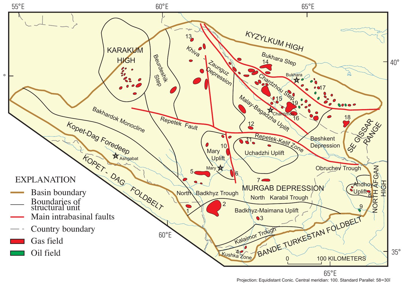
A US Geological Survey assessment of the petroleum geology of the Amu Darya basin, a major gas province in Turkmenistan and Uzbekistan that extends into Afghanistan and Iran. Its north-eastern part takes in the Bukhara and Chardzhou steps, where fault-bounded blocks of basement drop from the Kyzylkum high into the basin, and the Beshkent depression, where the base of the Jurassic lies deeper than 5 km. The two steps hold most of Uzbekistan’s gas, condensate and oil reserves in Upper Jurassic carbonates.
A Paleozoic basement and Permian–Triassic rift grabens are overlain by thick Lower–Middle Jurassic coal-bearing rocks, Callovian–Oxfordian carbonates with reefs, the thick Kimmeridgian–Tithonian salt of the Gaurdak Formation, and Cretaceous–Paleogene marine clastic rocks. The present-day geothermal gradient is relatively high, 3.0–3.5 °C per 100 m in most areas, which gives high formation temperatures in Lower–Middle Jurassic rocks at depth. The base of the Jurassic lies at 6–8 km in the Kopet-Dag foredeep and the Murgab depression and at 4–5 km in the Khiva-Zaunguz depression.
Upper Jurassic carbonates and the Hauterivian Shatlyk Bed sandstones are the main reservoirs. Reef limestones have the best properties, and carbonate porosity does not correlate with depth, while Lower–Middle Jurassic sandstones lose porosity quickly with depth. In the Murgab depression and nearby structures, reservoir pressures below the Gaurdak salt are abnormally high, while those above it are hydrostatic.
Figures (2)
How to cite
G. F. Ulmishek (2004). Petroleum Geology and Resources of the Amu-Darya Basin, Turkmenistan, Uzbekistan, Afghanistan, and Iran. U.S. Geological Survey Bulletin 2201-H, version 1.0. https://doi.org/10.3133/b2201H