ОтчетОткрытый доступ
Геология и ресурсы нефти и газа Амударьинского бассейна (Туркменистан, Узбекистан, Афганистан и Иран)
Petroleum Geology and Resources of the Amu-Darya Basin, Turkmenistan, Uzbekistan, Afghanistan, and Iran
https://doi.org/10.3133/b2201H
Ключевые данные
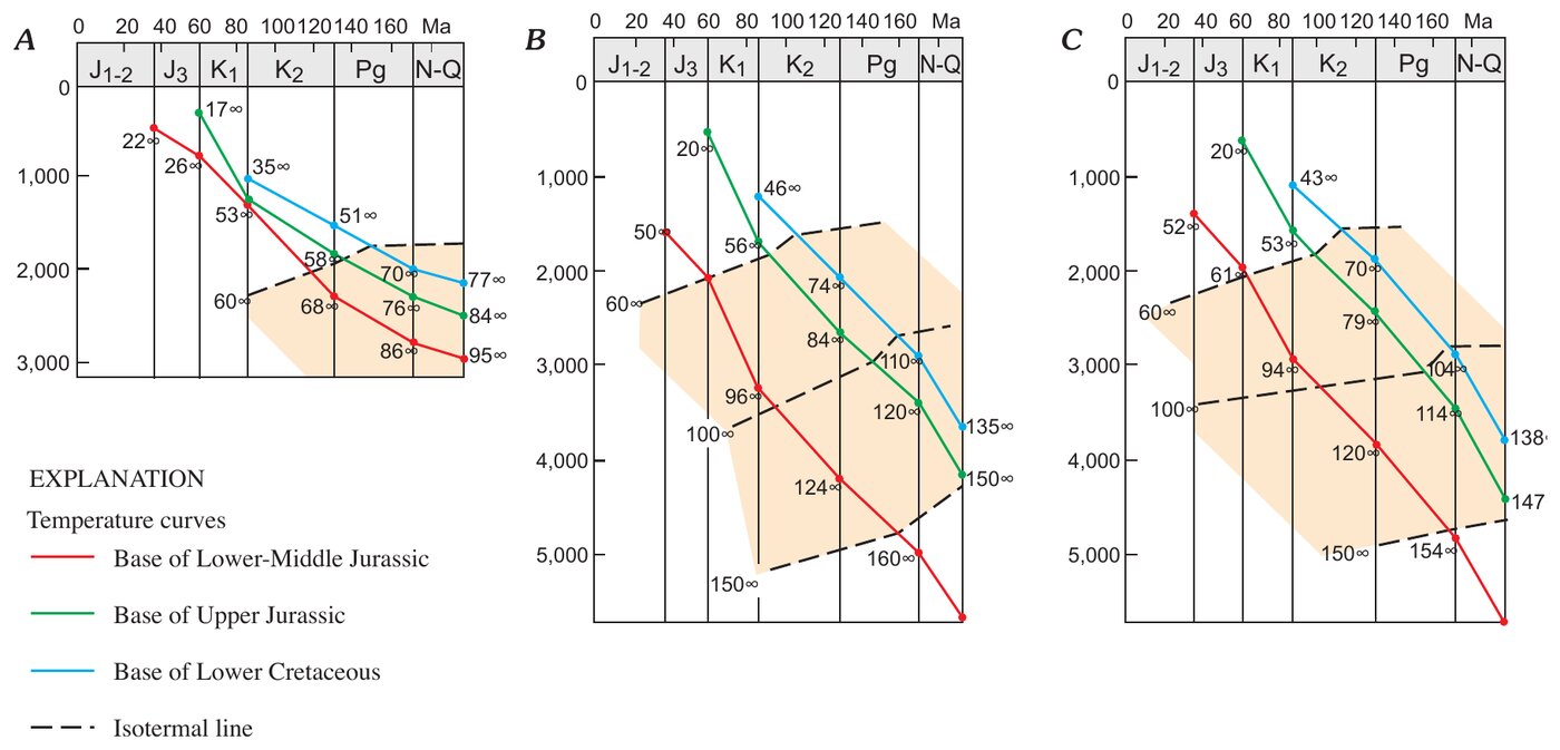
- Современный геотермический градиент — 3,0–3,5 °C на 100 м на большей части территории (Оводов и Печерников, 1987).
- Кровля верхнеюрских карбонатов на большей части бассейна — на глубине 3 000–5 000 м. Рифовые карбонаты: пористость 14–19%, проницаемость 25–400 мД, мощность коллекторов до 200 м; коллекторы бассейновой фации — 5,5–11% и 0,2–10 мД.
- Песчаники шатлыкского горизонта залегают в основном на глубине 3–3,5 км, мощность до 120–130 м: пористость рыхлых песчаников 25–33%, проницаемость обычно выше 1 000 мД.
- Нижне-среднеюрские песчаники на севере Хива-Заунгузской впадины на глубине около 2 км: пористость до 17,4%, проницаемость до 40 мД; на 2,5–3 км пористость обычно ниже 10%.
- Месторождение Газли на Бухарской ступени: 10 продуктивных пластов в верхнемеловых породах на глубине 50–1 200 м, пористость песчаников 13–23%, проницаемость — сотни миллидарси.
- Месторождение Даулетабад: в зоне гидродинамической связи с верхнеюрскими породами давление в шатлыкском коллекторе в 1,3 раза выше гидростатического, у северного и северо-западного газоводяного контакта — близко к гидростатическому. Восточнее газоводяного контакта в водах шатлыкского горизонта обнаружен растворенный сероводород.
Аннотация
The Amu-Darya basin is a highly productive petroleum province in Turkmenistan and Uzbekistan (former Soviet Union), extending southwestward into Iran and southeastward into Afghanistan. The basin underlies deserts and semideserts north of the high ridges of the Kopet-Dag and Bande-Turkestan Mountains. On the northwest, the basin boundary crosses the crest of the Karakum regional structural high, and on the north the basin is bounded by the shallow basement of the Kyzylkum high. On the east, the Amu-Darya basin is separated by the buried southeast spur of the Gissar Range from the Afghan-Tajik basin, which is deformed into a series of north-south-trending synclinoria and anticlinoria. The separation of the two basins occurred during the Neogene Alpine orogeny; earlier, they were parts of a single sedimentary province. The basement of the Amu-Darya basin is a Hercynian accreted terrane composed of deformed and commonly metamorphosed Paleozoic rocks. These rocks are overlain by rift grabens filled with Upper Permian-Triassic rocks that are strongly compacted and diagenetically altered. This taphrogenic sequence, also considered to be a part of the economic basement, is overlain by thick Lower to Middle Jurassic, largely continental, coal-bearing rocks. The overlying Callovian-Oxfordian rocks are primarily carbonates. A deep-water basin surrounded by shallow shelves with reefs along their margins was formed during this time and reached its maximum topographic expression in the late Oxfordian. In Kimmeridgian-Tithonian time, the basin was filled with thick evaporites of the Gaurdak Formation. The Cretaceous-Paleogene sequence is composed chiefly of marine clastic rocks with carbonate intervals prominent in the Valanginian, Barremian, Maastrichtian, and Paleocene stratigraphic units. In Neogene time, the Alpine orogeny on the basin periphery resulted in deposition of continental clastics, initiation of new and rejuvenation of old faults, and formation of most structural traps. A single total petroleum system is identified in the Amu-Darya basin. The system is primarily gas prone. Discovered gas reserves are listed by Petroconsultants (1996) at about 230 trillion cubic feet, but recent discoveries and recent reserve estimates in older fields should increase this number by 40 to 50 trillion cubic feet. Reserves of liquid hydrocarbons (oil and condensate) are comparatively small, less than 2 billion barrels. Most of the gas reserves are concentrated in two stratigraphic intervals, Upper Jurassic carbonates and Neocomian clastics, each of which contains about one-half of the reserves. Reserves of other stratigraphic units—from Middle Jurassic to Paleogene in age—are relatively small. Source rocks for the gas are the Lower to Middle Jurassic clastics and coal and Oxfordian basinal black shales in the east-central part of the basin. The latter is probably responsible for the oil legs and much of the condensate in gas pools. Throughout most of the basin both source-rock units are presently in the gas-window zone. Traps are structural, paleogeomorphic, and stratigraphic, as well as a combination of these types. The giant Dauletabad field is in a combination trap with an essential hydrodynamic component. Four assessment units were identified in the total petroleum system. One unit in the northeastern, northern, and northwestern marginal areas of the basin and another in the southern marginal area are characterized by wide vertical distribution of hydrocarbon pools in Middle Jurassic to Paleocene rocks and the absence of the salt of the Gaurdak Formation. The other two assessment units are stratigraphically stacked; they occupy the central area of the basin and are separated by the regional undeformed salt seal of the Gaurdak Formation. The largest part of undiscovered hydrocarbon resources of the Amu-Darya basin is expected in older of these assessment units. The mean value of total assessed resources of the Amu-Darya basin is estimated at 164 trillion cubic feet of gas and about 4 billion barrels of petroleum liquids, most of which is condensate.
Англоязычная аннотация взята из отчета. Авторская аннотация воспроизводится на условиях лицензии Public domain (USGS). Аннотация дана на английском языке.
Простыми словами
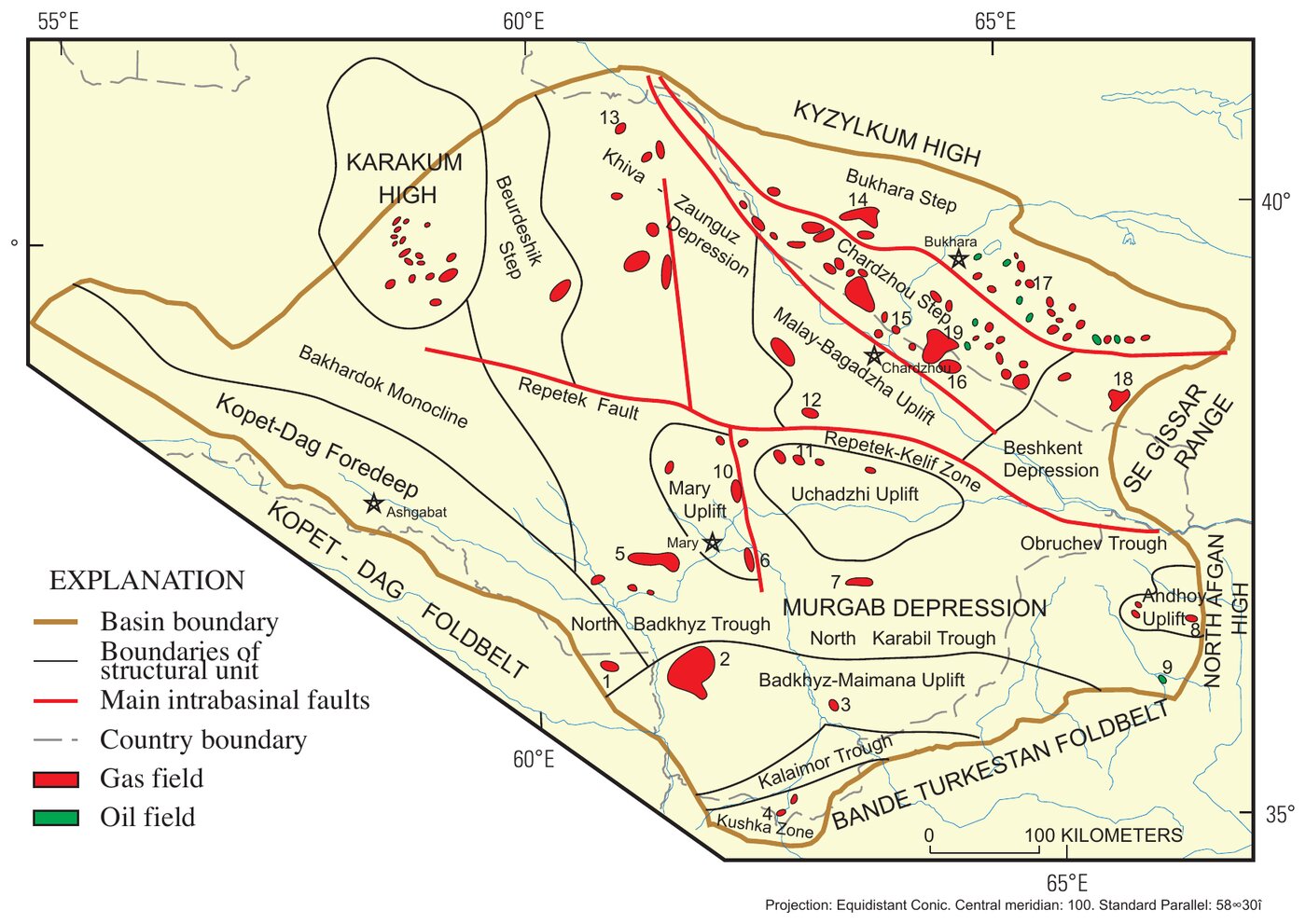
Оценка нефтегазовой геологии Амударьинского бассейна, выполненная Геологической службой США (USGS). Бассейн — крупная газоносная провинция Туркменистана и Узбекистана, заходящая в Афганистан и Иран. В его северо-восточную часть входят Бухарская и Чарджоуская ступени, где ограниченные разломами блоки фундамента ступенчато опускаются от Кызылкумского поднятия в бассейн, и Бешкентский прогиб, где подошва юры залегает глубже 5 км. На этих двух ступенях сосредоточена большая часть запасов газа, конденсата и нефти Узбекистана в верхнеюрских карбонатах.
Палеозойский фундамент и пермо-триасовые рифтовые грабены перекрыты мощными нижне-среднеюрскими угленосными породами, келловей-оксфордскими карбонатами с рифами, мощной кимеридж-титонской солью гаурдакской свиты и мел-палеогеновыми морскими обломочными породами. Современный геотермический градиент сравнительно высок — на большей части территории 3,0–3,5 °C на 100 м, поэтому пластовые температуры в глубоко залегающих нижне-среднеюрских породах высоки. Подошва юры лежит на глубине 6–8 км в Предкопетдагском прогибе и Мургабской впадине и на 4–5 км в Хива-Заунгузской впадине.
Главные коллекторы — верхнеюрские карбонаты и песчаники готеривского шатлыкского горизонта. Лучшие свойства — у рифовых известняков, причем пористость карбонатов не связана с глубиной, тогда как нижне-среднеюрские песчаники с глубиной быстро теряют пористость. В Мургабской впадине и на соседних структурах пластовые давления под гаурдакской солью аномально высокие, над ней — гидростатические.
Рисунки (2)
Как цитировать
G. F. Ulmishek (2004). Petroleum Geology and Resources of the Amu-Darya Basin, Turkmenistan, Uzbekistan, Afghanistan, and Iran. U.S. Geological Survey Bulletin 2201-H, version 1.0. https://doi.org/10.3133/b2201H