Jurnal maqolasiOchiq kirish
O‘zbekistondagi Oqtosh daryosi suv yig‘ish havzasida so‘nggi yigirma yildagi tog‘ gidrologik jarayonlarini miqdoriy baholash
Quantification of mountainous hydrological processes in the Aktash River watershed of Uzbekistan, Central Asia, over the past two decades
- Center for Bottomland Hardwoods Research, Southern Research Station, USDA Forest Service, Mississippi State, United States
- Institute of Forestry and Engineering, Estonian University of Life Sciences, Tartu, Estonia
- InNovaSilva ApS, Vejle, Denmark
- Center for Forest Health and Disturbance, US Forest Service, Athens, Georgia, United States
- Research Institute of Forestry, Tashkent, Uzbekistan
https://doi.org/10.3390/hydrology10080161
Asosiy jihatlar
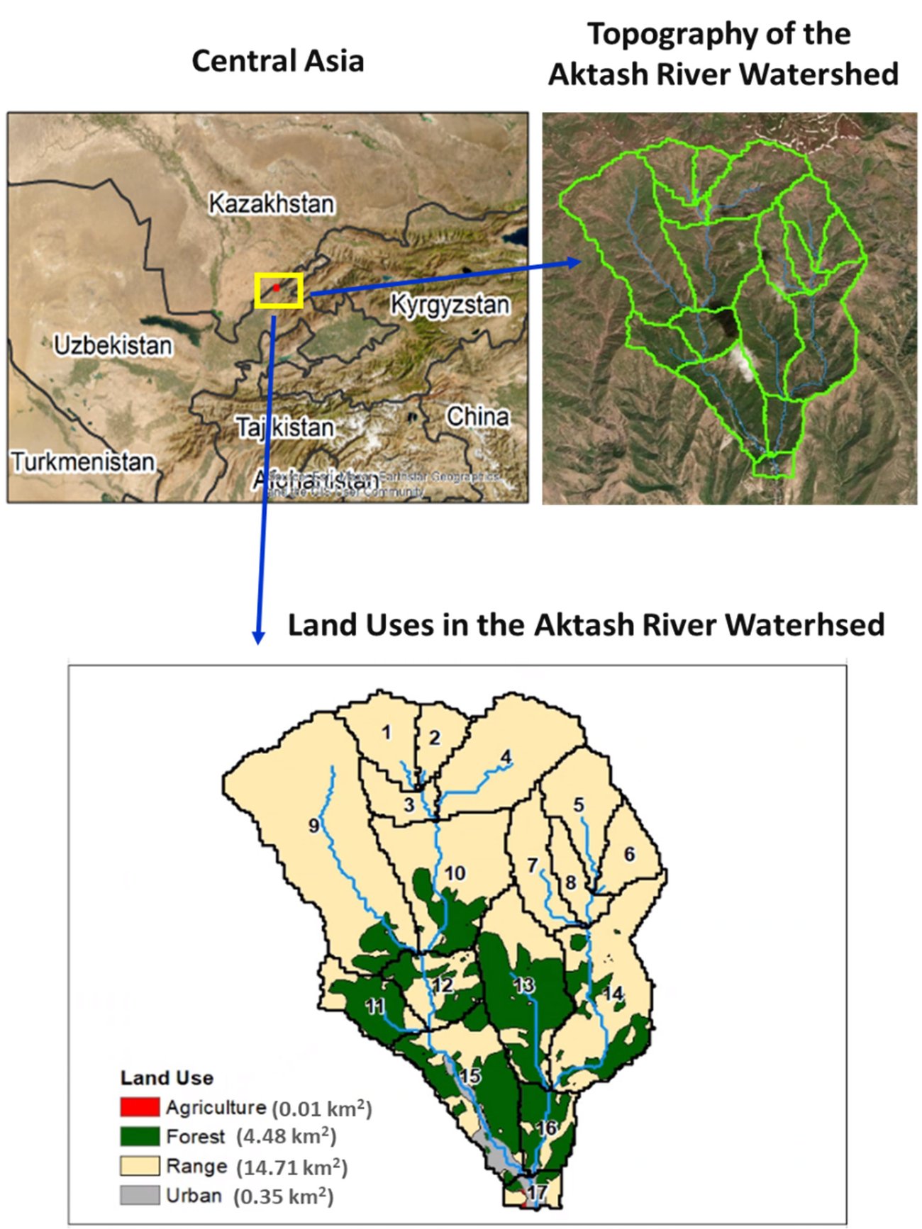
- Havza: 19,55 km², 1 100–1 600 m; yaylov 75,3%, o‘rmon 22,9%, aholi punktlari 1,8%; modelda 17 ta kichik havza.
- MODIS kunlik bug‘lanish ma’lumotlari bo‘yicha kalibrlash (2002–2012) va tekshirish (2013–2019): R² 0,66 va 0,63, Nesh–Satklif samaradorligi 0,06 va 0,27.
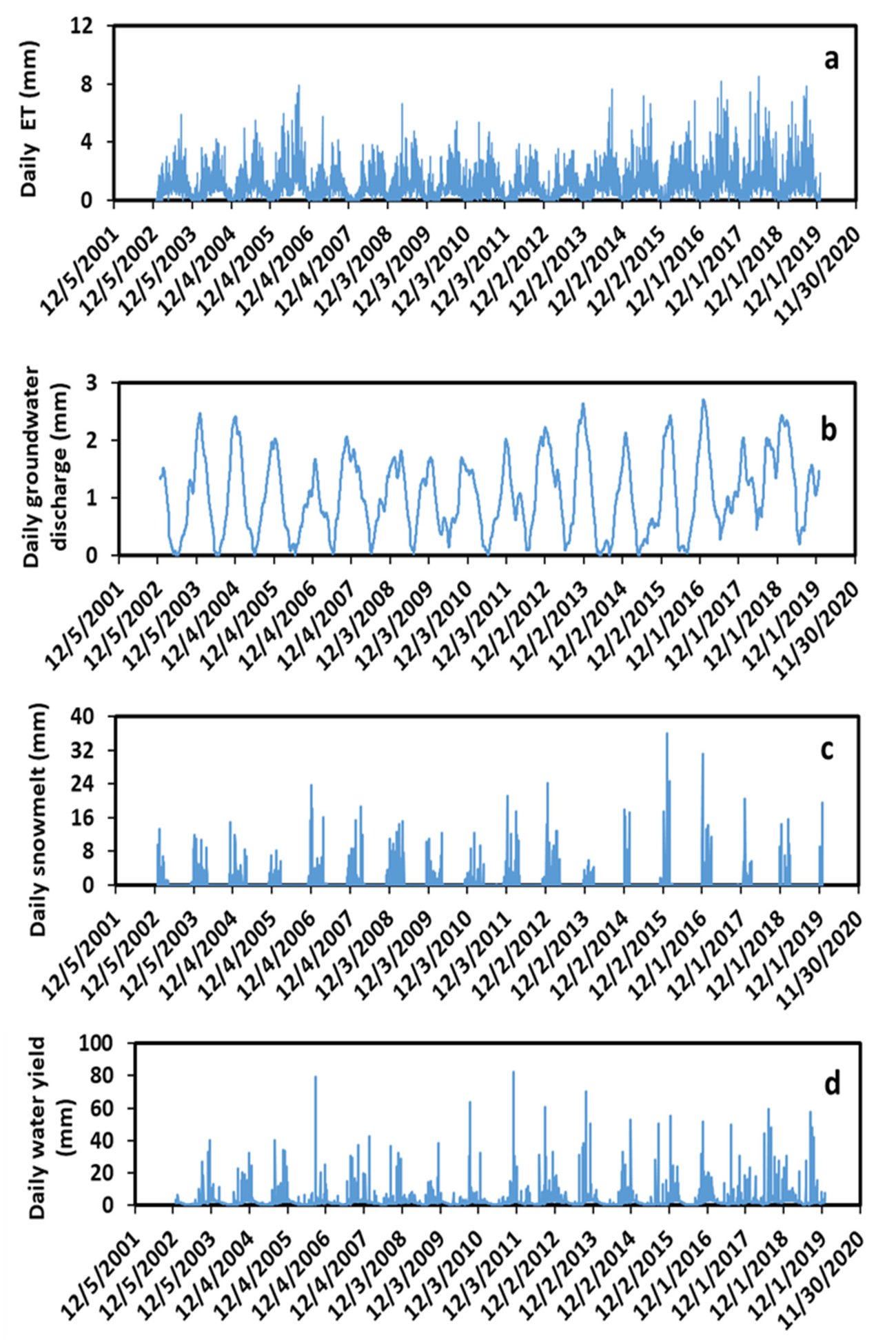
- 2003–2019-yillardagi yillik o‘rtacha qiymatlar: yog‘in 1 164 mm, suv chiqishi 837 mm, bug‘lanish 407 mm, yer osti suvlari chiqishi 384 mm, yer usti oqimi 278 mm, daryo oqimi 190 mm, qor erishi 140 mm.
- Fasllar bo‘yicha yer osti suvlari chiqishi: qish 138 mm, kuz 107 mm, bahor 64 mm, yoz 34 mm.
- Havza chiqishidagi o‘rtacha oqim: modellashtirilgan 0,52 m³/s (2003–2019); o‘lchangan 0,41 m³/s (1947–1965).
- O‘rmon va yaylov ustun bo‘lgan kichik havzalar taqqoslanganda: yer usti oqimi taxminan 20% kam, yer osti suvlari chiqishi taxminan 5% ko‘p.
Annotatsiya
Estimation of hydrological processes is critical to water resource management, water supply planning, ecological protection, and climate change impact assessment. Mountains in Central Asia are the major source of water for rivers and agricultural practices. The disturbance of mountain forests in the region has altered the hydrological processes and accelerated soil erosion, mudflow, landslides, and flooding. We used the SWAT (Soil and Water Assessment Tool) model calibrated and validated with remote sensing data to quantify the mountainous hydrological processes in the Aktash River watershed (ARW) of Uzbekistan, Central Asia. Simulations showed that the daily surface runoff and streamflow closely responded to daily precipitation. Groundwater discharge reached its maximum in winter because of snowmelt. The wet months were from July to December, and the dry months were from January to June. The magnitudes of the seasonal hydrological processes were in the following order: fall > summer > winter > spring for precipitation and surface runoff; summer > spring > fall > winter for evapotranspiration (ET); winter > spring > fall > summer for snowmelt; fall > winter > summer > spring for water yield and streamflow; and winter > fall > spring > summer for groundwater discharge. The Mann–Kendall statistical test revealed a significant increasing trend for the annual precipitation (τ = 0.45, p < 0.01) and surface runoff (τ = 0.41, p < 0.02) over the past 17 years from 2003 to 2019. Compared to rangeland, forested land decreased monthly and annual average surface runoff by 20%, and increased monthly and annual average groundwater recharge by about 5%. Agricultural land had much higher unit-area values (mm/km²/y) of ET, groundwater recharge, and water yield than those of urban, forest, and range lands. Our research findings provide useful information to farmers, foresters, and decision makers for better water resource management in the ARW, Central Asia, and other mountain watersheds with similar conditions.
Inglizcha annotatsiya maqoladan olingan. Mualliflar annotatsiyasi CC BY 4.0 litsenziyasi asosida keltirilgan. Annotatsiya ingliz tilida berilgan.
Kalit so‘zlar
- Markaziy Osiyo
- gidrologik jarayonlar
- tog‘ suv yig‘ish havzasi
- SWAT modeli
Sodda qilib aytganda
Mualliflar Qorjontog‘ning janubiy yonbag‘rida, Toshkentdan taxminan 60 km uzoqlikda, 1 100–1 600 m balandlikda joylashgan 19,55 km² maydonli Oqtosh daryosi havzasining SWAT modelini tuzgan. Havzaning to‘rtdan uch qismi yaylov, qariyb to‘rtdan bir qismi o‘rmon; o‘rmonning katta qismi 1898–1903 va 1910–1914-yillarda eroziya va sellarga qarshi zinapoyalarga ekilgan yong‘oq, eman va archadan iborat. So‘nggi yillar uchun daryo suvi sarfi o‘lchanmaganligi sababli model 2002–2012-yillar uchun kalibrlangan va 2013–2019-yillar uchun MODIS sun’iy yo‘ldoshining kunlik bug‘lanish ma’lumotlari bo‘yicha tekshirilgan (R² 0,66 va 0,63, Nesh–Satklif samaradorligi 0,06 va 0,27); ob-havo ma’lumotlari global ma’lumotlar xizmatidan olingan, so‘ngra 2003–2019-yillar modellashtirilgan.
2003–2019-yillardagi yillik o‘rtacha ko‘rsatkichlar: yog‘in 1 164 mm, suv chiqishi 837 mm, bug‘lanish 407 mm, yer osti suvlari chiqishi 384 mm, yer usti oqimi 278 mm, daryo oqimi 190 mm va qor erishi 140 mm. Yer osti suvlarining soylarga chiqishi qishda qor erishi hisobiga eng yuqori bo‘ladi — o‘rtacha kuniga 1,05 mm, ko‘pi bilan 2,71 mm — va yozda eng kam; sersuv oylar iyuldan dekabrgacha. Havza chiqishidagi modellashtirilgan o‘rtacha oqim, 0,52 m³/s, 1947–1965-yillarda o‘lchangan 0,41 m³/s ga yaqin.
2003–2019-yillarda yillik yog‘in (τ = 0,45, p < 0,01) va yer usti oqimi (τ = 0,41, p < 0,02) sezilarli oshgan, suv chiqishi, daryo oqimi va bug‘lanish esa sezilarli o‘zgarmagan. O‘rmon ustun bo‘lgan kichik havzada yer usti oqimi yaylov ustun bo‘lgan kichik havzadagidan taxminan 20% kam, yer osti suvlari chiqishi esa taxminan 5% ko‘p bo‘lgan; mualliflar buni o‘rmon barpo etish oqim va eroziyani kamaytirib, yer osti suvlarining to‘yinishini oshirishining dalili deb biladi.
Rasmlar (2)
Iqtibos namunasi
Y. Ouyang, J. A. Stanturf, M. D. Williams, E. Botmann and P. Madsen (2023). Quantification of mountainous hydrological processes in the Aktash River watershed of Uzbekistan, Central Asia, over the past two decades. Hydrology, 10(8), 161. https://doi.org/10.3390/hydrology10080161