Journal article (review)Open access
Petroleum Systems of the Shu-Sarysu Basin, Kazakhstan: A Review of Devonian–Permian Gas Potential
- International Center for Deposit Analysis and Development; Department of Chemical Processes and Industrial Ecology; Department of Geophysics and Seismology; Department of Petroleum Engineering, Satbayev University, Almaty, Kazakhstan
- School of Mechanical Engineering, Sharif University of Technology, Tehran, Iran
https://doi.org/10.3390/geosciences15060232
Highlights
- Basin about 840 × 300 km, about 160,000 km²; sedimentary fill more than 5,500 m.
- 12 gas fields; Amangeldy 884 Bcf, Pridorozhnoye 225 Bcf.
- Present thermal gradient 30–35 °C/km; Late Palaeozoic palaeo-gradient 4.3–4.5 °C/100 m.
- Rock-Eval: 405 samples from 29 wells; vitrinite reflectance 1.39–3.3%; Tmax 300–579 °C; Hydrogen Index below 75 mg HC/g TOC.
- Porosity: Famennian sandstones 7–27% (up to 12 mD); Early Carboniferous sandstones 3–21.6% (generally under 190 mD); Middle–Late Carboniferous 3–10% and Early Permian 19–22% (up to 133 mD).
- Formation pressures in the same intervals differ by up to 40% between fields; helium up to 0.83% in Moiynkum Trough gases.
Abstract
The Shu-Sarysu Basin in central-southern Kazakhstan remains one of the underexplored gas-prone provinces, with 12 discovered gas fields including Amangeldy (884 Bcf) and Pridorozhnoye (225 Bcf). In the context of global energy transition, such basins require integrated geological assessment to constrain exploration potential. Historical studies within the region were spatially limited and prematurely discontinued, resulting in fragmented datasets and a lack of modern interpretation. This review reassesses published geological data within a petroleum systems framework, applying contemporary geodynamic and stratigraphic concepts. Analysis shows that tectonostratigraphic evolution of the basin during Devonian–Permian time (390–250 Ma) favored formation of mature, gas-prone systems within structurally compartmentalized troughs, with effective source, reservoir, and seal configurations. Building on these findings, a three-tier classification of exploration zones is proposed based on system maturity, trap integrity, and gas shows, reflecting geological success probability. This provides a basis for prioritizing future exploration despite limited seismic and drilling coverage in many areas. Recommended priorities include digitization of archival data, structural modeling, modern geochemical and diagenetic analysis, and focused evaluation of promising areas to support future exploration.
English abstract from the paper. The authors’ abstract, reproduced under CC BY 4.0.
Keywords
- Shu-Sarysu Basin
- Kazakhstan
- Devonian–Permian succession
- petroleum systems
- gas prospectivity
- geological evolution
- stratigraphy and tectonics
- energy transition
In plain English
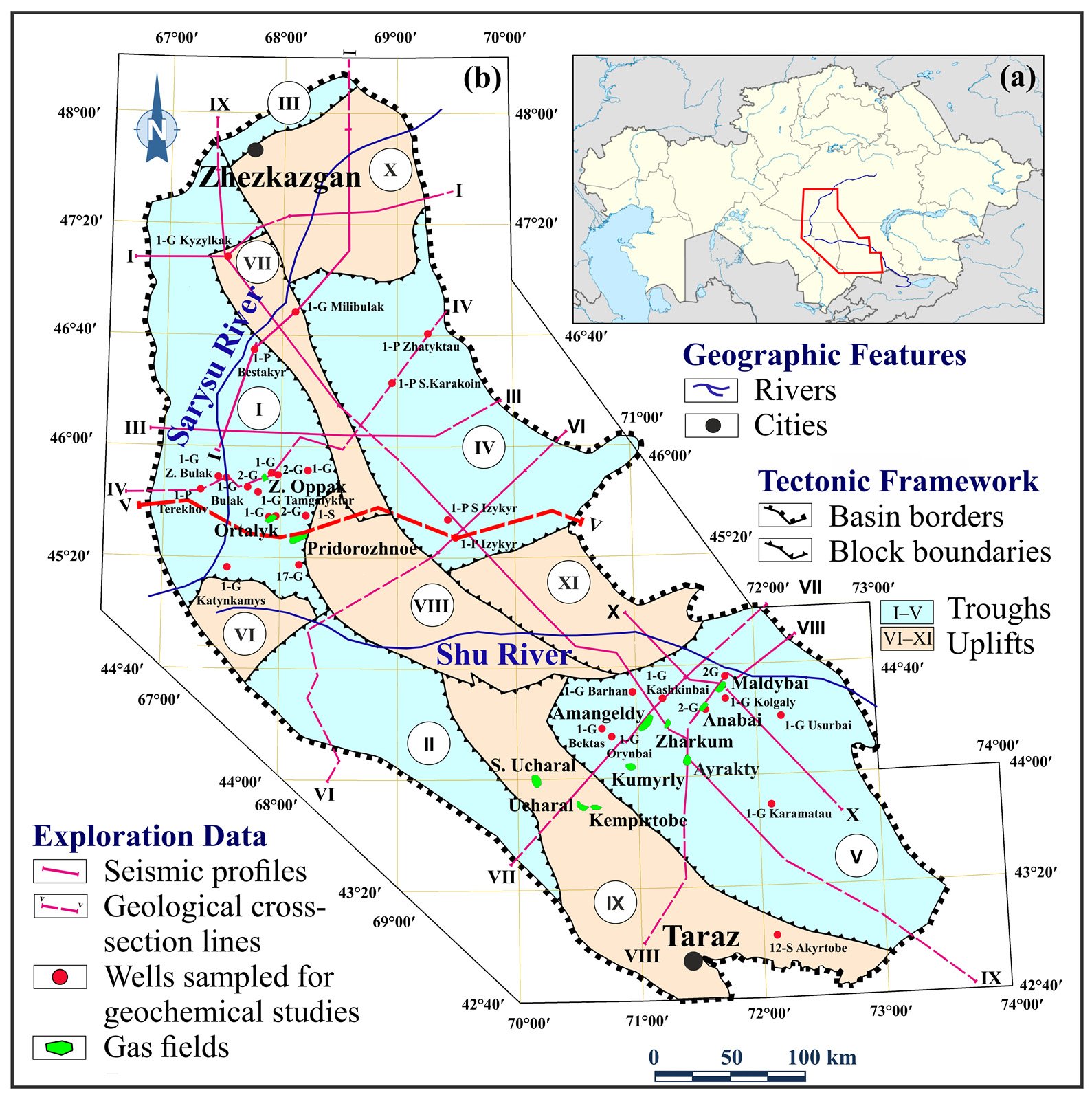
Almas Zhumagulov, Auez Abetov and Jamilyam Ismailova of Satbayev University and Mehrdad T. Manzari of Sharif University of Technology review published geological data on the Shu-Sarysu Basin in central and southern Kazakhstan within a petroleum systems framework. The basin lies in the Central Asian Orogenic Belt. It is about 840 km long from north-west to south-east and 300 km across, covers about 160,000 km², and its sedimentary fill is more than 5,500 m thick. The Karatau Ranges separate it from the Karatau–Syrdarya Basin to the south-west. Twelve gas fields have been found on the Talas Uplift and in the Moiynkum and Kokpansor troughs. The largest, Amangeldy (884 Bcf), lies mainly in Late Devonian–Early Carboniferous carbonates and Early Permian clastic rocks; Pridorozhnoye holds an estimated 225 Bcf. No new fields have been found since the 1980s.
Rock-Eval pyrolysis of 405 samples from 29 wells in 2003–2004 showed total organic carbon (TOC) below 1% in most samples and a Hydrogen Index below 75 mg HC/g TOC in all, typical of exhausted, gas-prone kerogen. The richest source rocks, with 1.5–6% TOC, are Visean coal-bearing lake and swamp deposits, mainly in the Tasbulak and Moiynkum troughs. Vitrinite reflectance of 1.39–3.3% and Tmax of 300–579 °C show mature to over-mature type III kerogen, more mature in the south of the basin than in the north. Modelling shows that the present thermal gradient of 30–35 °C/km and burial depths of up to 4.5 km cannot explain this maturity. It needs Late Palaeozoic palaeo-geothermal gradients of 4.3–4.5 °C/100 m, which the authors link to tectonic pulses and deep heat flow. Gases of the Moiynkum Trough contain up to 0.83% helium.
Famennian sandstones have porosities of 7–27% and permeabilities of up to 12 mD; Early Carboniferous sandstones have 3–21.6% and generally less than 190 mD. Middle–Late Carboniferous sandstones have 3–10% and Early Permian sandstones 19–22%, with permeabilities of up to 133 mD. Fractured Early Carboniferous limestones and fractured basement also hold gas. The basin is split into isolated troughs with mostly stagnant (elision-type) fluid regimes: formation pressures in the same intervals differ by up to 40% between fields. Laterally extensive evaporite seals limited upward migration of gas into the Permian.
The authors propose a three-tier classification of exploration zones by system maturity, trap integrity and gas shows. Zone I, at burial depths of 2,500–3,500 m, holds the proven fields, among them Amangeldy, Airakty, Zharkum and Maldybai. Large parts of the basin lack modern seismic and well data, and there are no direct temperature measurements in the north and on the margins. They recommend digitising archive data, structural modelling, and modern geochemical and diagenetic analyses.
Figures (1)
How to cite
Almas Zhumagulov, Auez Abetov, Mehrdad T. Manzari and Jamilyam Ismailova (2025). Petroleum Systems of the Shu-Sarysu Basin, Kazakhstan: A Review of Devonian–Permian Gas Potential. Geosciences, vol. 15, no. 6, 232. https://doi.org/10.3390/geosciences15060232