Journal articleFree to read
On the influence of the North Fergana fault on oil and gas formation
К вопросу влияния Северно-Ферганского разлома на нефтегазообразование
- Institute of Geology and Exploration of Oil and Gas Fields (IGIRNIGM), Tashkent, Uzbekistan
- Institute of Geology and Geophysics, Tashkent, Uzbekistan
Highlights
- Heat flow 207 mW/m² at Adrasman (Jarkamar area, well 2-0), the highest in the Tien Shan.
- Heat flow 110 mW/m² at Benamoz; 70–75 mW/m² at Makhram; 70–74 mW/m² in the Almas trough; 65–70 mW/m² between the Gava and Sumsar rivers.
- Chust-Pap well 1: total depth 5,835 m; 180–200 °C at 5,800 m.
- Muruldysay well 6: 204 °C at 5,500 m. Well 1 (Chust-Pap, Muruldysay): brine at 96 °C in the 2,496–3,580 m interval.
- Benamoz: base of the sedimentary cover at about 5,000 m, rock temperature 300 °C. Makhram: 100 °C isotherm at about 4,500–5,000 m.
- Kandysay brine discharge: 154 g/L, chloride–calcium, with iodine and bromine.
Keywords
- heat flow
- North Fergana fault
- Adrasman–Chust thermal anomaly
- Fergana basin
- deep well temperature
- brines
- Namangan region
Summary
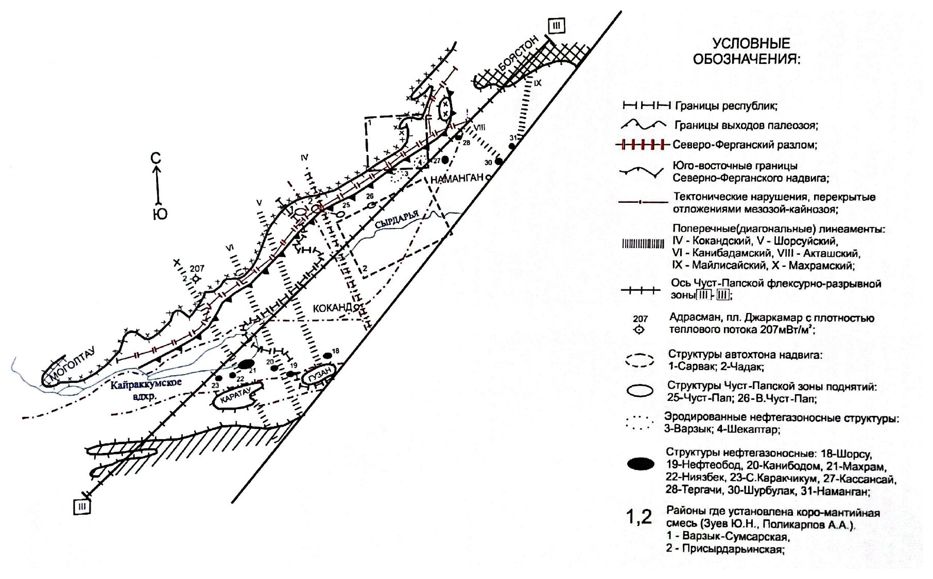
The authors, of the Institute of Geology and Exploration of Oil and Gas Fields (IGIRNIGM) and the Institute of Geology and Geophysics, review the North Fergana fault, which separates the Beltau-Kuramin volcanic arc from the Chatkal-Kuramin block. The fault was laid down no later than the Devonian and became active again in the Early Miocene. Most researchers place its roots in the mantle at 45–50 km. Paleozoic rocks are thrust over Cretaceous and Paleogene rocks along a belt up to 10–12 km wide. Where transverse north-west lineaments (Kokand, Makhram, Aktash and others) cross the fault, fractured and decompacted zones form channels that carry deep fluids from the basement into the sedimentary cover.
Heat flow is highest where the Makhram lineament meets the fault: 207 mW/m² at Adrasman (Jarkamar area, well 2-0), the highest in the Tien Shan. This is the Adrasman–Chust thermal anomaly, which covers the south-eastern slopes of the Kuramin range, the Akbel-Supetau ridge, the Chust-Pap uplift, the Almas and Pishkaran troughs and the south-east of the Namangan uplift. The anomaly is linked to cryptomagmatic processes and to heat carried along the fault. A channel of deep heat and mass transfer with 110 mW/m² is mapped at Benamoz; in a thermodynamic model of this channel, the base of the sedimentary cover lies at about 5,000 m, where rock temperature reaches 300 °C. At the Makhram field, 30 km to the south, heat flow is 70–75 mW/m² and the 100 °C isotherm lies at about 4,500–5,000 m. Heat flow is 70–74 mW/m² in the Almas trough and 65–70 mW/m² between the Gava and Sumsar rivers.
Well 1 on the Chust-Pap uplift, completed in December 2012 at 5,835 m, recorded 180–200 °C at 5,800 m. In well 1 (Chust-Pap, Muruldysay), chloride–calcium brines at 96 °C were met in the 2,496–3,580 m interval, with 196 mg/L of orthoboric acid; well 6 at Muruldysay recorded 204 °C at 5,500 m. In the core of the Chust-Pap uplift (Kandysay), hydrocarbon–nitrogen chloride–calcium brines of 154 g/L with iodine and bromine discharge at the surface. Springs in the upper Jidasay are alkaline and carbonated, with salinity up to 1 g/L and bromine up to 34 mg/L; the authors regard them as diluted derivatives of deep hydrotherms. The authors conclude that the heat flow follows the amplitude of recent tectonic movements.
Figures (1)
How to cite
G. S. Abdullayev, L. D. Shpora, G. G. Dzhalilov, L. P. Sharafutdinova, R. Z. Akhmerov, A. D. Gonchar and B. A. Sabirov (2015). On the influence of the North Fergana fault on oil and gas formation. O‘zbekiston neft va gaz jurnali (Uzbek Journal of Oil and Gas), No. 3, 2015, pp. 18–22. https://drive.google.com/file/d/1UT6AY2p8dDCfztWkOkP_9PwyzJeXFCWG/view