Journal articleFree to read
Oil and gas potential of the Jurassic terrigenous formation of the Dengizkul uplift
Перспективы нефтегазоносности юрской терригенной формации Денгизкульского поднятия
- Institute of Geology and Exploration of Oil and Gas Fields (IGIRNIGM), Tashkent, Uzbekistan
- National University of Uzbekistan, Tashkent, Uzbekistan
Highlights
- Thickness of the Jurassic terrigenous formation: 20–1,800 m.
- Umid area: wells penetrated only 3–76 m of the formation, from 3 m in well 10 to 76 m in well 17.
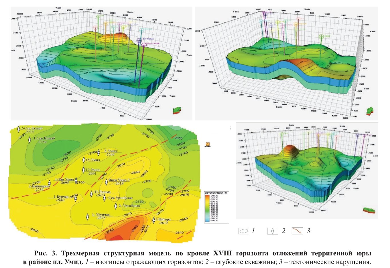
- Top of horizon XVIII on the Umid structure model (Fig. 3): −2,612 m in well Nigora 1 to −2,754 m in well North Kushab 1.
- Dengizkul uplift: permeability 0.0001–0.0008 darcy; porosity 6–7%.
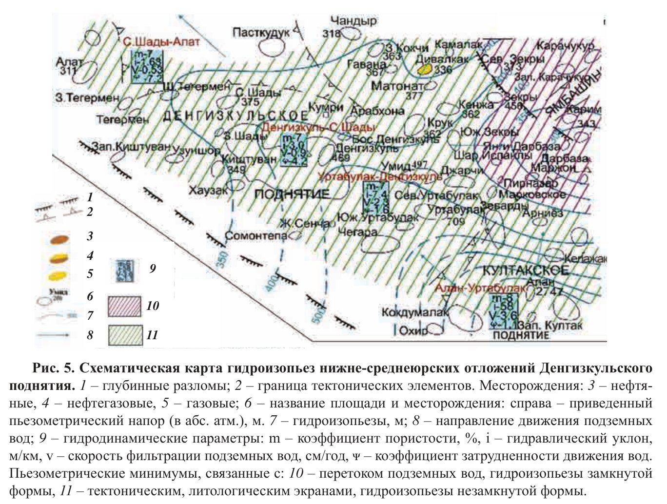
- Hydraulic gradient 7.4–58 m/km; filtration rate 2.3–3.6 cm per year; coefficient of hindered water movement 1.1–52.8.
- Reduced heads drop from 2,747 m at the Alan field to 709–469 m at Urtabulak, Umid and Dengizkul.
Abstract
This article discusses the oil and gas potential of the Lower and Middle Jurassic terrigenous deposits in the Dengizkul uplift of the Bukhara-Khiva region, based on geological, geophysical, lithological, facies, and hydrodynamic criteria. The study involved a detailed examination of the lithological and stratigraphic classification of the terrigenous formation deposits, as well as the facies conditions of sedimentation both vertically and horizontally. Additionally, the distribution of thicknesses and the location of productive horizons were analyzed. The research uncovered zones with channel sand deposits that exhibit good reservoir properties. It also identified areas where traps–related to anticlinal structures and the wedging out of specific horizons formed by sand bars–are likely present. Furthermore, hydrodynamic anomalies were identified, characterized by low hydraulic heads in both closed and open forms, indicating favorable zones for the formation and preservation of hydrocarbon deposits. In conclusion, the article presents key findings, evaluates the oil and gas potential of the Jurassic terrigenous deposits in the study area, and provides specific recommendations for future exploration efforts.
English abstract from the journal issue PDF. The authors’ abstract, reproduced under .
In plain English
Written for oil and gas, this paper examines the Lower and Middle Jurassic terrigenous formation of the Dengizkul uplift in the Bukhara–Khiva region. In the central and north-western parts of the Chardzhou step, this formation holds gas in horizons XVII–XX, mostly in shallow-marine and coastal sandstones sealed by clays and clay–carbonate beds. On the Dengizkul uplift, the extent of these horizons had not been mapped.
The formation consists of conglomerates, gravelstones, sandstones, siltstones, mudstones, coals and marls, and is 20 to 1,800 m thick. Its lower half (Pliensbachian to Bajocian) formed in foothill fans and valley plains, its upper half (upper Bajocian to lower Callovian) in surf-zone marine and underwater-delta settings, and its facies change sharply both laterally and vertically. At the Umid area, wells entered only the top 3–76 m of the formation, the Baysun suite (horizon XVII). There it has no reservoir rocks and consists mainly of lagoonal-marine grey clays with sandstone and siltstone interbeds.
At Umid, the top of horizon XVII forms a monocline dipping north towards the Kushab trough, and the top of horizon XVIII a north-east-trending brachyanticline with its crest near well Umid 17. Reinterpreted seismic data show, at depth, a high that probably marks the top of the pre-Jurassic rocks, and on the north-western slope the fill of an eroded channel. The authors conclude that pinch-outs and unconformities, together with river, delta and bar sand bodies, play the main role in forming traps.
New piezometric data for the Jurassic water-pressure complex were used to map heads and flow in the Lower–Middle Jurassic. Formation water moves mainly from the south and south-east to the north and north-west, except in some local areas inside uplifts. On the eastern flank of the uplift, reduced heads drop sharply from 2,747 m at the Alan field to 709–469 m at Urtabulak, Umid and Dengizkul, where hydraulic gradients and filtration rates are highest. The Mubarek low in pressure head extends west to the eastern Dengizkul uplift (Shoda, Darbaza, Jarchi, Umid and other areas); the authors class these lows as mainly barrier-type, with hidden upward discharge playing a minor part. Water exchange in the formation is mainly by infiltration but very slow, because the reservoir beds are discontinuous and their properties change sharply.
Figures (2)
How to cite
T. Kh. Shoimurotov, Z. O. Omonboev, O. D. Bolibekov and U. Ch. Tukhtaev (2025). Oil and gas potential of the Jurassic terrigenous formation of the Dengizkul uplift. Geologiya i mineral'nye resursy (Geology and Mineral Resources), No. 4, 2025, pp. 20–25. https://mridm.uz/en/assets/journal/pdf/4_2025.pdf