Journal articleOpen access
Hydrogeochemical features of groundwater in the Mesozoic sediments of the Bukhara-Khiva oil and gas region
Гидрогеохимические особенности подземных вод мезозойских отложений Бухаро-Хивинского нефтегазоносного региона
https://doi.org/10.25689/NP.2024.2.44-72
Highlights
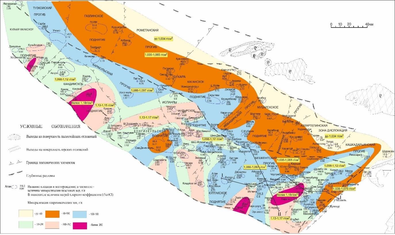
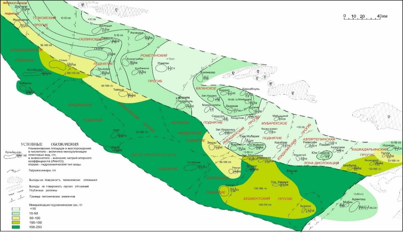
- Formation-water salinity in the Mesozoic deposits: 1–335 g/L, in places 400 g/L or more; in the Cretaceous deposits 1–231 g/L.
- Average salinity by complex: Jurassic 4.0–219.0 g/L (chloride–calcium type); Neocomian–Aptian 2.0–157.0 g/L; Albian–Cenomanian 1.6–145.0 g/L; Senonian–Paleocene 0.8–22.0 g/L.
- Thickness: Jurassic complex 30–1,900 m; Neocomian–Aptian 200–600 m; Albian–Cenomanian 150–500 m; Eocene clay cap 200–270 m.
- Lower–Middle Jurassic brines in the Beshkent trough reach 284.0 g/L at Shurtan, 330.3 g/L at Nishan and 333.5 g/L at Izgancha; Upper Jurassic water in well Eshonkuduk-1 reaches 407.2 g/L.
- Upper Jurassic brines carry 57.7–67.9 mg/L of iodine (Urtabulak–Kokdumalak) and up to 987 mg/L of bromine (South Zekry).
- Reservoirs: Lower–Middle Jurassic sandstones 5–12% porosity and 10–200 mD permeability; Jurassic carbonates 12–16% and 4–20 mD on average; Albian–Cenomanian sands on the Bukhara step up to 30% and 1,000 mD or more.
Abstract
The article examines the current state of hydrogeochemical zoning of Mesozoic deposits of the Bukhara-Khiva oil and gas region. Groundwater plays an important role in the formation and preservation of oil and gas deposits; under certain conditions, they can contribute to their accumulation or destruction; therefore, the purpose of the study is to establish the role of groundwater in the formation and placement of hydrocarbons in the Mesozoic water system of the Bukhara-Khiva region. The work used an integrated approach to solving problems, including scientific generalizations of factual data in the context of Jurassic and Cretaceous deposits of the study area with the use of materials characterizing the hydrogeochemical parameters of formation waters. From a general geological point of view, consideration of the hydrogeological features of groundwater, the unity of the dynamics and chemistry of formation fluids are an important oil exploration criterion and deserves attention when choosing a rational direction for geological exploration. Based on the hydrogeological analysis of the Jurassic and Cretaceous deposits of the BKHNGR, the hydrogeochemical zones and the location of individual promising areas with respect to oil and gas potential were clarified. The discovery of such local areas of the study area significantly expands the range of search objects, which in the future will improve the efficiency of prospecting and exploration work. Conclusions are presented with an assessment of the oil and gas potential of the study area based on hydrogeochemical criteria. The hydrogeochemical studies proposed in the work have an undeniable advantage, since the hydrogeological aspect under consideration is based on the analysis of data from previous structural-tectonic, lithological-facial, geochemical, geophysical studies and acts as the final generalizing result.
English abstract from the article PDF. The authors’ abstract, reproduced under CC BY 4.0.
Keywords
- hydrogeochemical zone
- sediments
- formation water
- aquifer complex
- mineralization
- horizon
- fluid
- deposit
- migration
- Jurassic
- Cretaceous
- Mesozoic
In plain English
Written for oil and gas exploration, this paper describes the chemistry of formation water in the Mesozoic rocks of the Bukhara–Khiva region. The region is the north-eastern part of the Amu Darya water-pressure system, between the South Kyzylkum and Amu Darya faults. It is divided into three hydrogeological areas: Bukhara, Chardzhou and Beshkent–Kashkadarya.
The aquifers rest on a Palaeozoic basement 3.0–3.5 to 5.0–5.5 km deep. Clay and salt seals divide them into a Jurassic complex (horizons XX–XV) and three Cretaceous complexes: Neocomian–Aptian (XIV–XII), Albian–Cenomanian (XI–IX) and Senonian–Paleocene (VIII–VII). Eocene clays cap the whole system. Reservoir quality is best in the centre of the region and falls with depth.
Salinity ranges from 1 to 335 g/L, and in places reaches 400 g/L or more. It rises along the regional dip, from the Bukhara step towards the Chardzhou step and the Beshkent trough. The deep Jurassic waters are mostly chloride–calcium brines, often rich in iodine and bromine. Cretaceous waters are more varied; the least saline, of infiltration origin, lie in the Albian–Cenomanian beds of the Bukhara step. The authors conclude that today’s hydrochemical zoning is largely inherited from earlier stages of the basin’s history, and that infiltrating water has flushed only the margins of the system.
Figures (2)
How to cite
T. Kh. Shoimurotov, I. N. Khakimzyanov and J. Sh. Ziyaev (2024). Hydrogeochemical features of groundwater in the Mesozoic sediments of the Bukhara-Khiva oil and gas region. Neftyanaya Provintsiya, No. 2(38), pp. 44–72. https://doi.org/10.25689/NP.2024.2.44-72