Journal articleFree to read
The state of the hydrocarbon potential of the Cretaceous sediments of Western Uzbekistan and the prospects for increasing oil and gas reserves
Состояние углеводородного потенциала меловых отложений Западного Узбекистана и перспективы приращения запасов нефти и газа
- Institute of Geology and Exploration of Oil and Gas Fields (IGIRNIGM), Tashkent, Uzbekistan
Highlights
- Cretaceous formation water: 1–231 g/L, from 560 samples taken at 84 areas and fields.
- Senonian water of the Bukhara step: 1.38 g/L (Azlyartepa dislocation zone) to 9.52 g/L (Gazli uplift); Upper Cretaceous water of the Chardzhou step: 10.0 g/L (Kulbeshkak uplift) to 52.3 g/L (Beshkent trough).
- Lower Cretaceous water: 2.3 g/L (Azlyartepa) to 20.7 g/L (Mubarek uplift) on the Bukhara step; 100–150 g/L in the Kashkadarya trough (Shurasan, Yakkasaray); 48.0–112 g/L (Ispanly-Chandyr and Kultak uplifts) to 230.5 g/L (Kulbeshkak uplift) on the Chardzhou step.
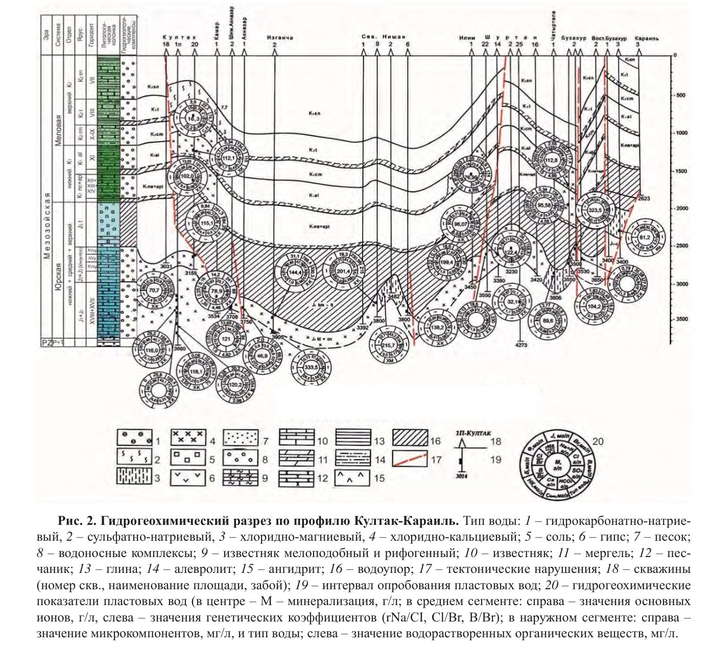
- Kultak–Karail section: at Buzakhur, Upper Jurassic water over 300.0 g/L in places, Neocomian–Aptian 113.6 g/L, Albian–Cenomanian 112.8 g/L; at Ilim, Upper Jurassic about 200 g/L, Albian–Cenomanian 80 g/L.
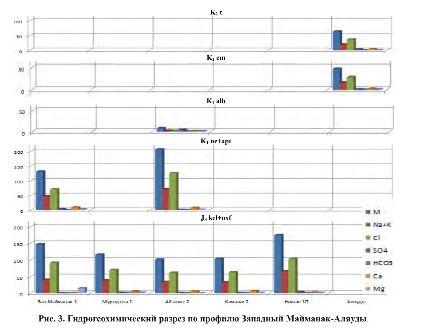
- West Maimanak–Alyaudy section: at West Maimanak, Upper Jurassic 145.1 g/L and Neocomian–Aptian 131.2 g/L; at Aizavat, Upper Jurassic over 100 g/L and Neocomian–Aptian 206.4 g/L; at Alyaudy, Cenomanian 46.5 g/L and Turonian 63.6 g/L.
- Upper Jurassic heads along the Lyangar–Karail fault: 1,096 m at Karail, 800–900 m at the Buzakhur field.
- Salt and anhydrite formation between the Jurassic and the Cretaceous in the south of the region: 400–1,000 m thick.
Abstract
The geological prerequisites for the oil and gas content of the Cretaceous sediments of Western Uzbekistan are considered, the role of tectonic and hydrogeological factors in the formation and preservation of hydrocarbon sediments is shown. The role of groundwater in the formation and distribution of hydrocarbons in the Cretaceous sediments of Western Uzbekistan has been established. The study of the hydrochemical composition of groundwater and the nature of their dynamic movements due to geological and tectonic processes is a necessary condition for assessing the prospects for the oil and gas potential of territories. An integrated approach to solving problems was applied, including scientific generalizations of actual data in the context of the Cretaceous sediments of the study area with the involvement of materials characterizing the hydrogeochemical and hydrodynamic parameters of formation fluids. The areas most characteristic in terms of hydrocarbon accumulation in various traps associated with tectonic and lithological screens, which are favorable zones for the accumulation and preservation of hydrocarbon deposits, have been identified.
English abstract from the journal issue PDF. The authors’ abstract, reproduced under .
In plain English
Written for oil and gas exploration, this paper reconsiders the prospects of the Cretaceous rocks of Western Uzbekistan. In the south of the region, a salt and anhydrite formation 400–1,000 m thick separates them from the Jurassic, and most fields there produce only from Callovian–Oxfordian carbonates. Where the salt is missing or is reduced to 20–25 m of anhydrite, Cretaceous beds are productive too. The Cretaceous consists of three sequences: Neocomian–Aptian, Albian–Cenomanian and Turonian–Senonian.
The authors processed 560 formation-water samples from 84 areas and fields, with more than 15,000 chemical determinations. Cretaceous water ranges from 1 to 231 g/L. The least saline water, with clear signs of infiltration origin, lies in the Senonian beds of the Bukhara step: 1.38–9.52 g/L, mainly of bicarbonate–sodium and sulphate–sodium type. Upper Cretaceous water on the Chardzhou step holds 10.0–52.3 g/L. Lower Cretaceous water holds 2.3–20.7 g/L on the Bukhara step, 100–150 g/L as chloride–calcium brine in the Kashkadarya trough and 48.0–230.5 g/L on the Chardzhou step.
Four types of vertical hydrochemical section occur: normal, where salinity and other parameters rise with depth; partly normal, where they rise at the transition to the Albian–Cenomanian aquifer; partly inverse, with a minimum in the Albian–Cenomanian; and inverse, where they fall with depth. Two hydrogeochemical sections compare Upper Jurassic and Cretaceous water at the same fields. At Buzakhur, Upper Jurassic water exceeds 300 g/L in places, while the Neocomian–Aptian and Albian–Cenomanian water above it holds 113.6 and 112.8 g/L. At West Maimanak, Upper Jurassic and Neocomian–Aptian water is almost the same, 145.1 and 131.2 g/L, both of chloride–sodium–calcium type. The authors read such likeness as a direct sign of fluids moving upwards.
Along the Lyangar–Karail fault, heads in the Upper Jurassic fall from 1,096 m at Karail to 800–900 m at Buzakhur. There, Cretaceous horizons XII and XIV hold weak chloride–calcium brines of 98.8–114.6 g/L with dissolved organic matter typical of Upper Jurassic water. The authors conclude that large faults both block lateral flow and let water move between layers, and they place prospective zones near the Bukhara, Amu Darya and Lyangar–Karail faults. The paper focuses on the Cretaceous; a 2024 regional study covers Jurassic and Cretaceous water together.
Figures (2)
How to cite
T. Kh. Shoimurotov, N. Sh. Khayitov, M. A. Akhadov and U. A. Nuriddinov (2022). The state of the hydrocarbon potential of the Cretaceous sediments of Western Uzbekistan and the prospects for increasing oil and gas reserves. Geologiya i mineral'nye resursy (Geology and Mineral Resources), No. 5, 2022, pp. 76–83. https://mridm.uz/en/assets/journal/pdf/5_2022.pdf