Journal articleFree to read
Hydrogeological aspects of oil and gas potential of Mesozoic deposits of the Bukhara-Khiva oil and gas region
Гидрогеологические аспекты нефтегазоносности мезозойских отложений Бухаро-Хивинского нефтегазоносного региона
- Institute of Geology and Exploration of Oil and Gas Fields (IGIRNIGM), Tashkent, Uzbekistan
Highlights
- Salinity of Mesozoic formation water: 1–335 g/L, in places 400 g/L or more.
- Depth of the Palaeozoic basement, the floor of the aquifers: 1.0–2.0 km on the Bukhara step, 3.0–5.5 km on the Chardzhou step.
- Data: 560 Cretaceous samples from 84 areas and fields and 1,621 Jurassic samples from 166; more than 25,000 chemical determinations.
- Chlorine-to-salinity ratio (Cl/M) most often 0.55–0.61, ocean average 0.55; rNa/rCl of Jurassic water 0.70–0.93.
- Normalised calcium 4.0–42.0 (seawater 2.1); normalised bicarbonate in Albian–Cenomanian transition zones from 18.7–185.5 to 447.8 at Azlyartepa (seawater 0.59–0.74).
- Maximum normalised iodine 1.5–7.86 (seawater 0.003), on the Mubarek, Kulbeshkak, Kandym, Ispanly-Chandyr and Dengizkul uplifts and in the Beshkent trough.
- Normalised bromine 2.19–12.13 in the Albian–Cenomanian (seawater 3.4); 28.3 at Azlyartepa and 51.9 at Karaktay in the Neocomian–Aptian; mostly under 5.0 in the Jurassic.
- Normalised boron 0.5–34.3 in Cretaceous water; in Jurassic water 0.07–0.73 at the lowest, 3.82 at Shirkuduk and 2.57–4.07 on the Chardzhou step.
Abstract
The article deals with the hydrogeological aspects of the oil and gas content of the Mesozoic deposits of the Bukhara-Khiva oil and gas region. Based on the study of the normalized values of macro-and microcomponents and their metamorphization of water-pressure complexes, the hydrochemical conditions of formation waters of the Mesozoic deposits of Bukhara-Khiva oil and gas region were refined. The study of the nature of the hydrochemical field in the regional plan, taking into account the peculiarities of the vertical and horizontal zonality of waters, in some of its gas and oil areas and regions, revealed the hydrochemical zonality of fluids in the Jurassic and Cretaceous deposits. For the identified hydrochemical regions of the Bukhara-Khiva oil and gas region, statistically substantiated, quantitatively expressed characteristics of the chemical composition of groundwater have been established, which make it possible to recognize changes in the chemical composition along the lateral and vertical lines and to assess the migration of fluids, as well as its effect on the process of generation of hydrocarbon deposits. The continuity of the water migration of chemical elements, hydrocarbons and, in general, the unity of the dynamics and chemistry of underground fluids are the important point that in many ways determines their oil prospecting value in specific geological conditions.
English abstract from the journal issue PDF. The authors’ abstract, reproduced under .
In plain English
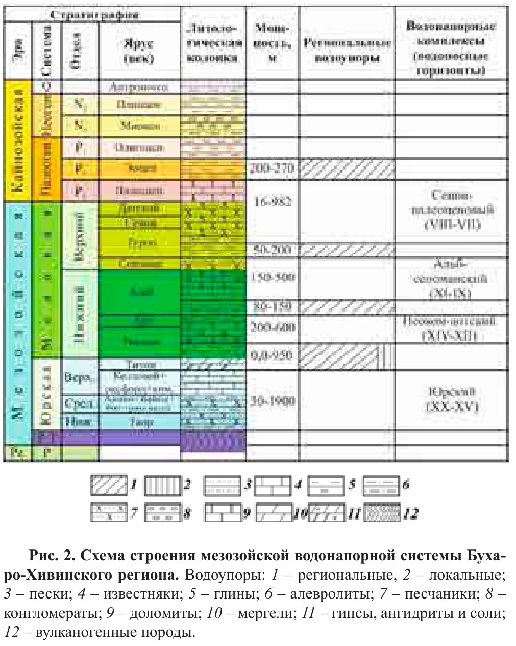
Written for oil and gas exploration, this paper reviews formation water in the Mesozoic rocks of the Bukhara–Khiva region, the north-eastern part of the Amu Darya water-pressure system. The region is bounded by the South Kyzylkum and Prezarafshan faults in the north, by the Zarafshan range and the south-western spurs of the Gissar range in the east and south-east, and by the Amu Darya fault in the south. The aquifers rest on a Palaeozoic basement 1.0–2.0 km deep on the Bukhara step and 3.0–5.5 km deep on the Chardzhou step. Aquitards divide them into a Jurassic complex and three Cretaceous complexes; in the far north-west, around Gazli, Meshekli and Yangikazgan, the Lower Cretaceous and the Jurassic form a single complex.
Salinity ranges from 1 to 335 g/L, in places 400 g/L or more, and rises along the regional dip from the Bukhara step to the Chardzhou step. Water of under 50 g/L forms a narrow strip in the north-east, and water of 50–100 g/L covers almost all of the Bukhara step. Chloride–calcium brines of 100–150 g/L occupy mainly the Chardzhou step and the Kagan and Mubarek uplifts. Brines of 200–250 g/L and more lie on the Kulbeshkak, Kandym, Ispanly-Chandyr and Dengizkul uplifts and in the Karakul and Beshkent troughs.
The authors processed 560 Cretaceous and 1,621 Jurassic water samples, more than 25,000 chemical determinations, and compared the ratios of ions to chlorine with those of seawater. The chlorine share of salinity is most often 0.55–0.61, close to the ocean average of 0.55. Normalised calcium is 4.0–42.0, against 2.1 in seawater, which the authors explain by calcium taken up from the host rocks. Bicarbonate is an order of magnitude above seawater values and iodine several orders, so the authors conclude that both built up after the sediments were laid down. Jurassic water is mostly of chloride–calcium type, with rNa/rCl of 0.70–0.93.
Four types of vertical hydrochemical section occur, from normal, with salinity rising with depth, to inverse, with salinity falling with depth; inverse sections appeared in many wells once exploration moved to the south and south-east of the region. The authors identify upward migration of fluids from Jurassic into Cretaceous aquifers on the Bukhara step at Mullakhol, Atbakor, Karaktay and Yakkasaray, and on the Chardzhou step at Akkum, Alat, Alan, Gugurtli, Dengizkul–Zevarda, Beshkent–Aknazar and Shurtan. The region’s salinity zones are mapped in a 2024 study; this paper adds the comparison with seawater and the types of vertical section.
Figures (1)
How to cite
T. H. Shoimuratov, O. A. Karshiev, M. A. Gaffarov, S. A. Rabbimkulov and I. Z. Kholmurodov (2023). Hydrogeological aspects of oil and gas potential of Mesozoic deposits of the Bukhara-Khiva oil and gas region. Geologiya i mineral'nye resursy (Geology and Mineral Resources), No. 4, 2023, pp. 65–70. https://mridm.uz/en/assets/journal/pdf/4_2023.pdf