ReportOpen access
Assessment of undiscovered conventional oil and gas resources in the Amu Darya Basin and Afghan-Tajik Basin Provinces of Turkmenistan, Uzbekistan, Tajikistan, Afghanistan, and Iran, 2026
- U.S. Geological Survey, United States
https://doi.org/10.3133/fs20263024
Highlights
- Gaurdak Formation (Kimmeridgian–Tithonian) salt and anhydrite: up to 900 m thick.
- Early Cretaceous to Oligocene fill of the deeper grabens: up to 7 km of sandstones, mudstones and minor carbonates.
- Callovian–Oxfordian source shales: organic carbon up to 15 weight-percent, up to 250 m thick, mainly type-IIS kerogen.
- Undiscovered mean resources: 442 MMBO oil (F95–F5 288–634), 217,970 BCFG gas (125,527–333,944), 3,048 MMBNGL natural gas liquids (1,753–4,682).
- Amu Darya Mesozoic–Cenozoic Reservoirs assessment unit: median 700 (maximum 1,400) undiscovered gas fields and 75 (150) oil fields; mean 214,078 BCFG gas in gas accumulations and 399 MMBO oil.
- Afghan-Tajik Mesozoic–Cenozoic Reservoirs assessment unit: median 60 (maximum 120) gas fields and 10 (20) oil fields; mean 3,685 BCFG gas and 43 MMBO oil.
Abstract
Using a geology-based assessment methodology, the U.S. Geological Survey estimated undiscovered, technically recoverable mean conventional resources of 442 million barrels of oil and 218 trillion cubic feet of gas in the Amu Darya Basin and Afghan-Tajik Basin Provinces of Turkmenistan, Uzbekistan, Tajikistan, Afghanistan, and Iran.
Abstract from the fact sheet. The authors’ abstract, reproduced under Public domain (USGS).
In plain English
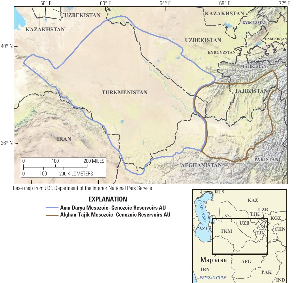
A team of the US Geological Survey (USGS) led by C. J. Schenk assessed the undiscovered, technically recoverable conventional oil and gas of the Amu Darya Basin and Afghan-Tajik Basin provinces of Turkmenistan, Uzbekistan, Tajikistan, Afghanistan and Iran, using a geology-based method. The two basins were a single geologic unit until Miocene compression linked to the collision of the Pamir block separated them. The petroleum geology of the Amu Darya basin is described in more detail in Ulmishek (2004).
Both basins began as Early to Middle Jurassic horsts and grabens formed by extension behind a volcanic arc. The grabens filled with thick Lower to Middle Jurassic nonmarine sandstones, mudstones, coal beds and carbonaceous shales. As extension slowed, the sea advanced and formed widespread Callovian–Oxfordian carbonate platforms, with organic-rich calcareous shales in the basins beside them. Slight uplift in the Kimmeridgian–Tithonian left up to 900 m of salt and anhydrite of the Gaurdak Formation. From the Early Cretaceous to the Oligocene up to 7 km of sandstones, mudstones and minor carbonates were laid down in the deeper grabens. Miocene contraction formed broad folds and anticlines in the Amu Darya Basin, which hold many of its oil and gas reservoirs, and thrusts and folds in the Afghan-Tajik Basin.
In the Amu Darya Basin the USGS defined a Mesozoic Composite total petroleum system with two presalt source rocks: Lower to Middle Jurassic coal beds, carbonaceous shales and lacustrine shales, with coal the main source of gas, and Callovian–Oxfordian bituminous marls and shales with up to 15 weight-percent organic carbon, up to 250 m thick, mainly of type-IIS kerogen. These are modelled to be mainly in the gas window across the basin, except in a narrow zone along its margins. The presalt reservoirs are carbonates (reefs, dolomites, karst, ooid shoals and debris flows) partly sealed by the Gaurdak salt; the deepest may be highly overpressured and naturally fractured. The postsalt reservoirs are Cretaceous to Oligocene sandstones, the most important being those of the Lower Cretaceous Shatlyk Formation. In the Afghan-Tajik Basin, Paleogene marine shales may be an extra source rock, and the Neogene Pamir collision may have caused oil and gas to migrate again or escape from earlier traps.
The mean estimate of undiscovered resources is 442 million barrels of oil (F95–F5 range 288–634), 217,970 billion cubic feet of gas, or about 218 trillion cubic feet (125,527–333,944), and 3,048 million barrels of natural gas liquids (1,753–4,682). The Amu Darya assessment unit holds a mean of 399 million barrels of oil and 214,078 billion cubic feet of gas in gas accumulations; the Afghan-Tajik unit 43 million barrels and 3,685 billion cubic feet.
Figures (1)
How to cite
C. J. Schenk, T. J. Mercier, P. A. Le, A. D. Cicero, S. E. Gelman, J. S. Hearon, B. G. Johnson, J. H. Lagesse and H. M. Leathers-Miller (2026). Assessment of undiscovered conventional oil and gas resources in the Amu Darya Basin and Afghan-Tajik Basin Provinces of Turkmenistan, Uzbekistan, Tajikistan, Afghanistan, and Iran, 2026. U.S. Geological Survey Fact Sheet 2026–3024, 4 pp.. https://doi.org/10.3133/fs20263024