Journal articleOpen access
Quantification of mountainous hydrological processes in the Aktash River watershed of Uzbekistan, Central Asia, over the past two decades
- Center for Bottomland Hardwoods Research, Southern Research Station, USDA Forest Service, Mississippi State, United States
- Institute of Forestry and Engineering, Estonian University of Life Sciences, Tartu, Estonia
- InNovaSilva ApS, Vejle, Denmark
- Center for Forest Health and Disturbance, US Forest Service, Athens, Georgia, United States
- Research Institute of Forestry, Tashkent, Uzbekistan
https://doi.org/10.3390/hydrology10080161
Highlights
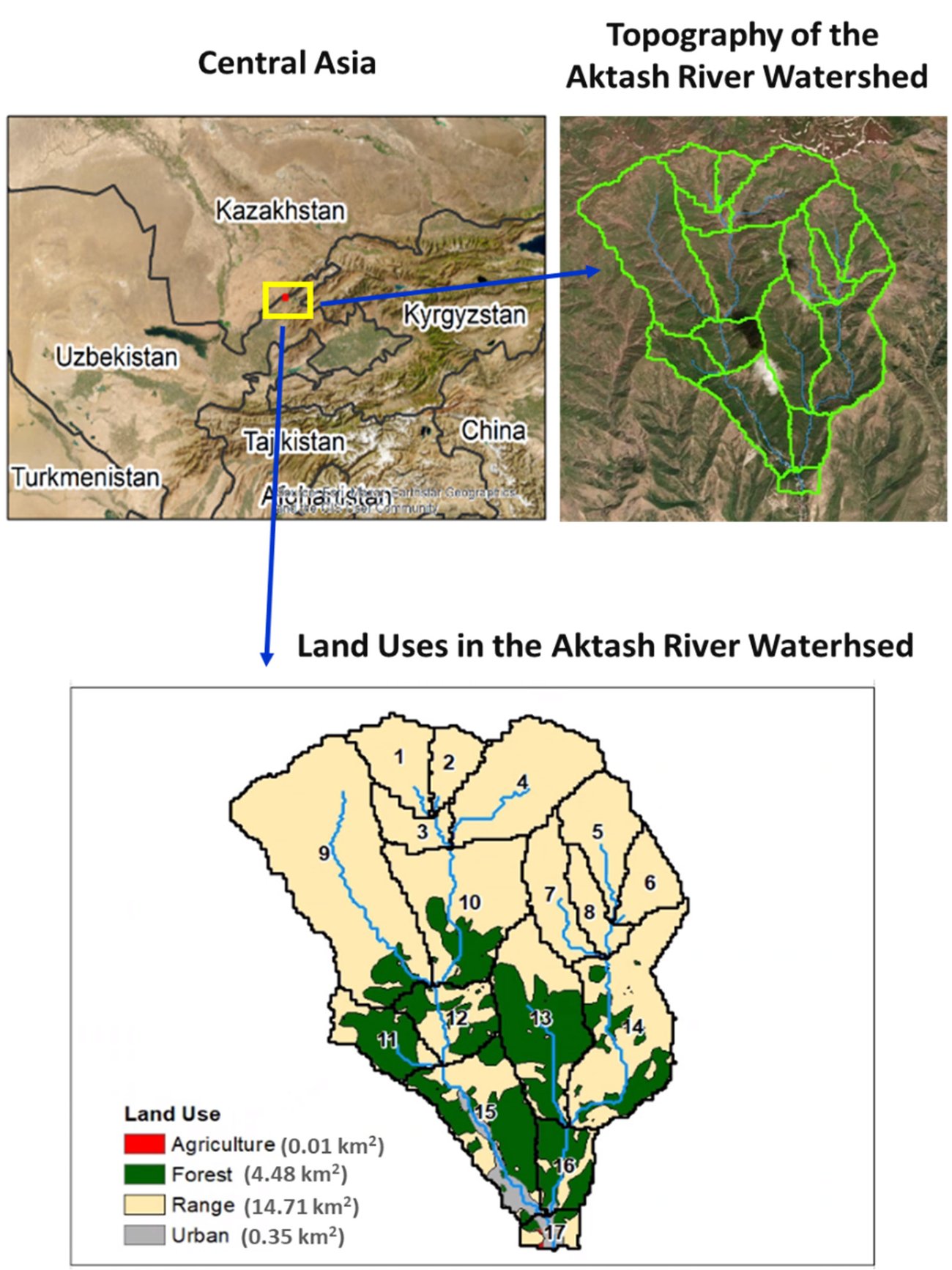
- Watershed: 19.55 km² at 1,100–1,600 m; rangeland 75.3%, forest 22.9%, urban 1.8%; 17 catchments in the model.
- Calibration (2002–2012) and validation (2013–2019) against MODIS daily evapotranspiration: R² 0.66 and 0.63, Nash–Sutcliffe efficiency 0.06 and 0.27.
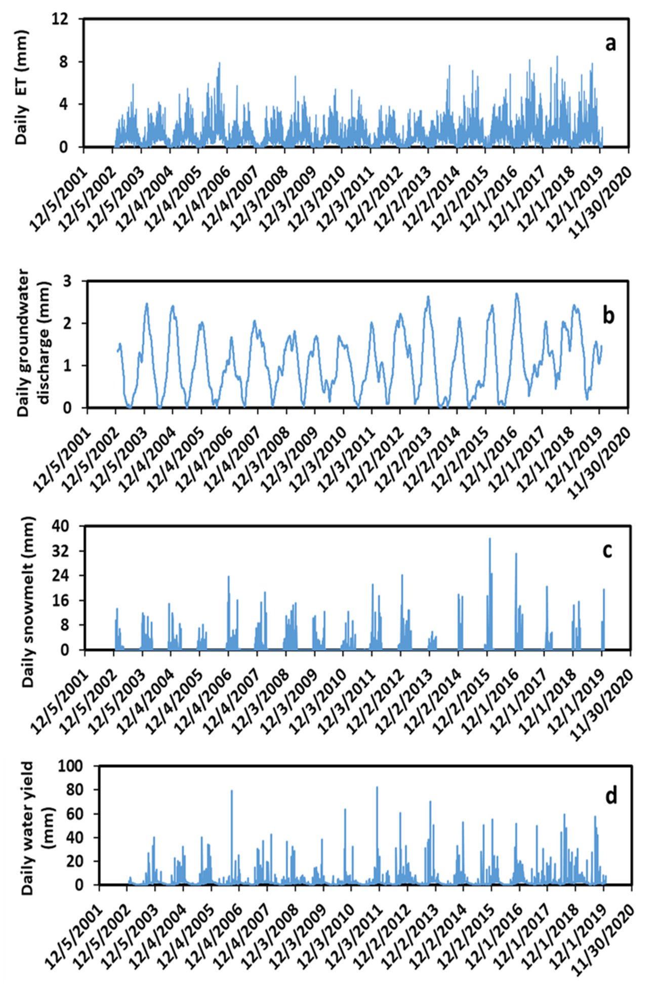
- Annual averages, 2003–2019: precipitation 1,164 mm, water yield 837 mm, evapotranspiration 407 mm, groundwater discharge 384 mm, surface runoff 278 mm, streamflow 190 mm, snowmelt 140 mm.
- Seasonal groundwater discharge: winter 138 mm, fall 107 mm, spring 64 mm, summer 34 mm.
- Mean streamflow at the outlet: simulated 0.52 m³/s (2003–2019); measured 0.41 m³/s (1947–1965).
- Forest- against rangeland-dominated catchment: surface runoff about 20% lower, groundwater discharge about 5% higher.
Abstract
Estimation of hydrological processes is critical to water resource management, water supply planning, ecological protection, and climate change impact assessment. Mountains in Central Asia are the major source of water for rivers and agricultural practices. The disturbance of mountain forests in the region has altered the hydrological processes and accelerated soil erosion, mudflow, landslides, and flooding. We used the SWAT (Soil and Water Assessment Tool) model calibrated and validated with remote sensing data to quantify the mountainous hydrological processes in the Aktash River watershed (ARW) of Uzbekistan, Central Asia. Simulations showed that the daily surface runoff and streamflow closely responded to daily precipitation. Groundwater discharge reached its maximum in winter because of snowmelt. The wet months were from July to December, and the dry months were from January to June. The magnitudes of the seasonal hydrological processes were in the following order: fall > summer > winter > spring for precipitation and surface runoff; summer > spring > fall > winter for evapotranspiration (ET); winter > spring > fall > summer for snowmelt; fall > winter > summer > spring for water yield and streamflow; and winter > fall > spring > summer for groundwater discharge. The Mann–Kendall statistical test revealed a significant increasing trend for the annual precipitation (τ = 0.45, p < 0.01) and surface runoff (τ = 0.41, p < 0.02) over the past 17 years from 2003 to 2019. Compared to rangeland, forested land decreased monthly and annual average surface runoff by 20%, and increased monthly and annual average groundwater recharge by about 5%. Agricultural land had much higher unit-area values (mm/km²/y) of ET, groundwater recharge, and water yield than those of urban, forest, and range lands. Our research findings provide useful information to farmers, foresters, and decision makers for better water resource management in the ARW, Central Asia, and other mountain watersheds with similar conditions.
English abstract from the paper. The authors’ abstract, reproduced under CC BY 4.0.
Keywords
- Central Asia
- hydrological processes
- mountain watershed
- SWAT model
In plain English
The authors built a SWAT model of the Aktash River watershed, 19.55 km² on the southern slope of the Karzhantau, about 60 km from Tashkent, at 1,100–1,600 m. Three-quarters of it is rangeland and almost a quarter forest, much of it from terraced plantings of walnut, oak and juniper in 1898–1903 and 1910–1914 against erosion and mudflows. With no measured river flow for recent years, the model was calibrated for 2002–2012 and validated for 2013–2019 against daily evapotranspiration from the MODIS satellite (R² 0.66 and 0.63, Nash–Sutcliffe efficiency 0.06 and 0.27), with weather data from a global data service, and then simulated 2003–2019.
Annual averages over 2003–2019 were 1,164 mm of precipitation, 837 mm of water yield, 407 mm of evapotranspiration, 384 mm of groundwater discharge, 278 mm of surface runoff, 190 mm of streamflow and 140 mm of snowmelt. Groundwater discharge to the streams peaks in winter, fed by snowmelt, at a mean of 1.05 mm and up to 2.71 mm a day, and is lowest in summer; the wet months are July to December. Mean simulated streamflow at the outlet, 0.52 m³/s, is close to the 0.41 m³/s measured in 1947–1965.
Annual precipitation (τ = 0.45, p < 0.01) and surface runoff (τ = 0.41, p < 0.02) rose significantly over 2003–2019, while water yield, streamflow and evapotranspiration did not change significantly. In the forest-dominated catchment, surface runoff was about 20% lower and groundwater discharge about 5% higher than in the rangeland-dominated one, which the authors take as evidence that afforestation cuts runoff and erosion and adds to groundwater recharge.
Figures (2)
How to cite
Y. Ouyang, J. A. Stanturf, M. D. Williams, E. Botmann and P. Madsen (2023). Quantification of mountainous hydrological processes in the Aktash River watershed of Uzbekistan, Central Asia, over the past two decades. Hydrology, 10(8), 161. https://doi.org/10.3390/hydrology10080161