Journal articleFree to read
Some features of the formation of the geological environment of the southeastern part of the dry bottom of the Aral Sea
Некоторые особенности формирования геологической среды юго-восточной части обсохшего дна Аральского моря
- O‘zbekgidrogeologiya, Tashkent, Uzbekistan
Highlights
- Survey of 2015–2023: 17 wells 50–730 m deep and 20 pits 1.5–2.2 m deep.
- Shallow groundwater: 7.7–76 g/L, total hardness 49–200 mg-eq/L and more, pH 7.7–8.1; well yields 0.1–0.8 L/s at 2.7–7.6 m drawdown; hydraulic conductivity of clayey sandstones 0.1–5.3 m/day.
- Water table down 0.5–1.0 m in 30 years, now at 1.5–2.5 m; on the bed exposed last, brines of 75–140 g/L less than 0.5–1.0 m deep.
- Upper Senonian–Palaeogene clay and marl aquitard: 280–540 m thick.
- Turonian–Lower Senonian aquifer: top at 380–520 m depth (absolute elevation minus 360–500 m); piezometric levels at absolute elevations of +70–40 m, 0.5–15 m above ground.
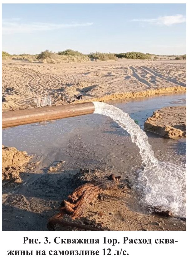
- Test pumping and free flow: 4.0–12 L/s at 14–22 m drawdown; well 1or flows freely at 12 L/s.
- Hydraulic conductivity 4.8–20.3 m/day; transmissivity 330–360 m²/day; piezoconductivity 4.3–4.58 × 10⁵ m²/day.
- Water of the deep aquifer: 1.4–1.9 g/L, total hardness 2.6–6.5 mg-eq/L, 38–41 °C.
Abstract
On the dry bottom of the Aral Sea, the features of the formation of a new geological environment are considered under the influence of the processes of salinity of the soils of the aeration zone and eol alteration of the relief. Descriptions of hydrogeological, engineering-geological and geoecological conditions are given, which are reflected on the corresponding maps. Some of the laws of the formation of the geological environment were determined, and an integral assessment of the change in ecological-geological conditions was given.
English abstract from the journal issue PDF. The authors’ abstract, reproduced under .
In plain English
In 2015–2023, a hydrogeological and engineering-geological survey of sheet L-41-XXXI on the dried south-eastern bed of the Aral Sea repeated the mapping done there in 1990–1995 and covered the sheet’s previously unstudied north-eastern part. Seventeen wells 50–730 m deep, 20 pits and five vertical electrical sounding profiles were made, with test pumping, water analyses and a year of level monitoring.
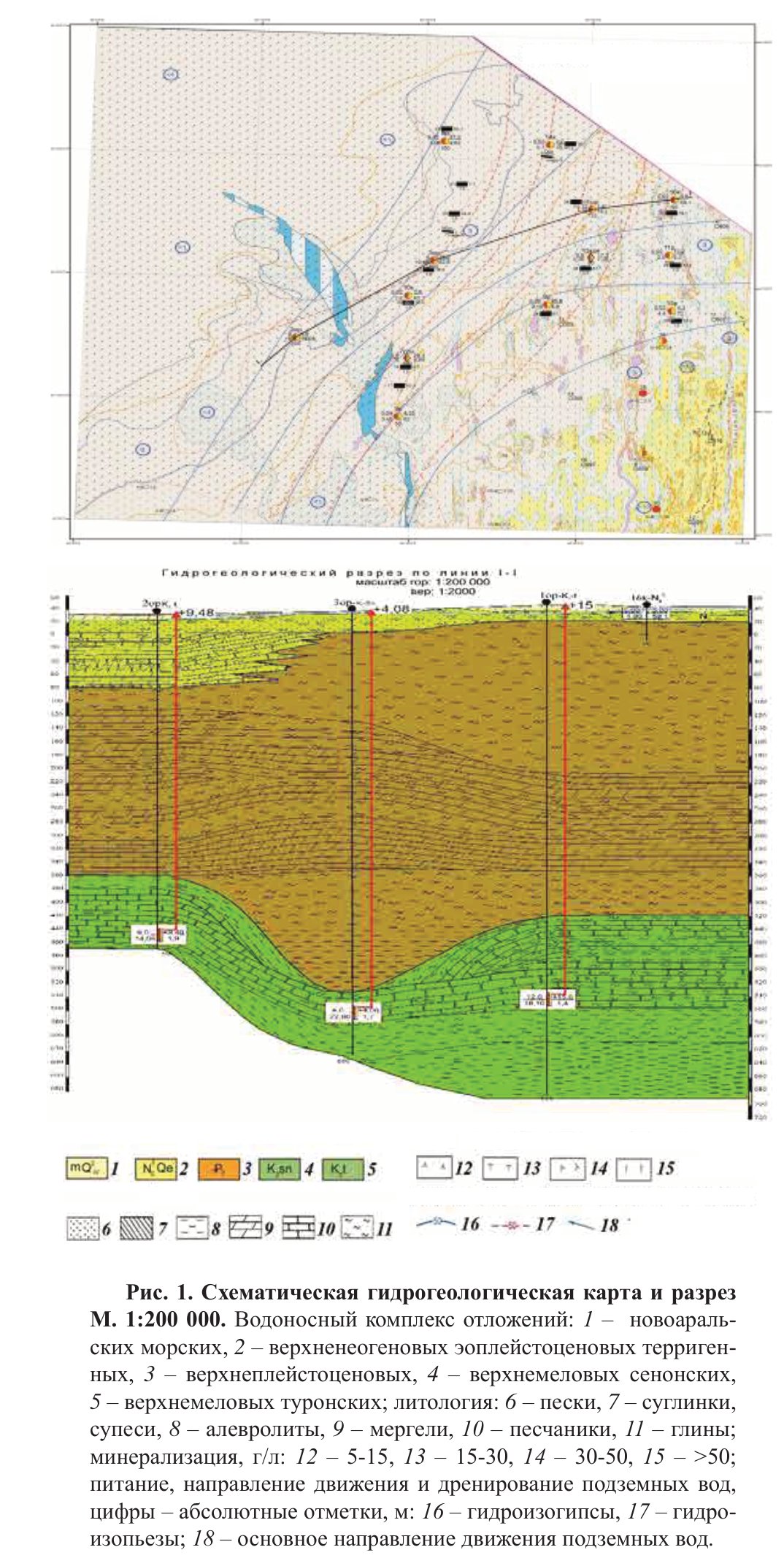
The shallow aquifers, in Quaternary New Aral marine deposits and Upper Pliocene–Eopleistocene sands and sandstones, carry chloride and sulphate–chloride sodium water of 7.7–76 g/L. Wells yield 0.1–0.8 L/s. Over 30 years the water table has fallen by 0.5–1.0 m and now lies 1.5–2.5 m below ground. On the bed exposed during the latest retreat of the sea, brines of 75–140 g/L lie less than 0.5–1.0 m deep and are lost mainly by evaporation through the soil. Below the shallow aquifers lies an aquitard of Upper Senonian–Palaeogene marine clays and marls 280–540 m thick.
Beneath it, the wells opened a confined aquifer in Turonian–Lower Senonian fine-grained sands, less often sandstones, with layers of clay and siltstone. Its top lies 380–520 m deep, 360–500 m below sea level, and its water rises 0.5–15 m above the ground, so the wells flow freely; well 1or flows at 12 L/s. The water is slightly brackish (1.4–1.9 g/L), of sulphate–chloride type, and 38–41 °C. Such water had not been found on the dried sea bed before. The authors recommend further study of the aquifer for drinking water, tourism, irrigation of tree plantations and technical needs, and as a possible source of hydrothermal energy.
Figures (2)
How to cite
T. E. Mavlyanov and M. A. Iztileuov (2024). Some features of the formation of the geological environment of the southeastern part of the dry bottom of the Aral Sea. Geologiya i mineral'nye resursy (Geology and Mineral Resources), No. 2, 2024, pp. 97–105. https://mridm.uz/en/assets/journal/pdf/2_2024.pdf