Journal articleOpen access
Assessment of Water Quality of the Trans-Boundary Zarafshan River in the Territory of Uzbekistan
- Department of Applied Ecology, National University of Uzbekistan, Tashkent, Uzbekistan
- Department of Geography, Philipps-Universität Marburg, Marburg, Germany
https://doi.org/10.4236/jwarp.2013.51003
Highlights
- Zarafshan River: 781 km long, basin 143,000 km², long-term mean discharge 190 m³/s.
- Seven sampling points from Ravatkhoja (Tajik–Uzbek border) to 0.8 km below the Navoiazot outlet at Navoi; annual means for 2002–2006, 2008 and 2009.
- Nitrate 0.52–3.60 mg/L (limit 45 mg/L); ammonium 0.01–0.12 mg/L (limit 0.39 mg/L); iron 0.01–0.15 mg/L (limit 0.5 mg/L).
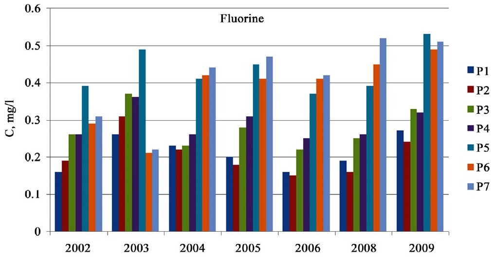
- Fluorine about 0.2 mg/L at Ravatkhoja, rising downstream (limit 0.75 mg/L).
- Arsenic up to 5.5 µg/L (2005) and zinc 11 µg/L (2003) at Ravatkhoja; limits 0.05 mg/L and 0.01 mg/L.
- Hexavalent chromium at Navoi two to three times the limit of 0.001 mg/L in 2002–2003; about 3.8 µg/L below the city.
- Collector-drainage water in Navoi region, 2004–2006: mineralisation 1.45–2.77 g/L, sulphate 702–1,352 mg/L, chloride 56.5–167 mg/L.
- Drainage discharge: Samarkand region 1.23–1.50 km³ a year (2002–2004); Navoi region 0.75–0.88 km³ a year (2002–2005).
Abstract
The Zarafshan river is a main trans-boundary river of the Aral Sea basin. As the main water resource, the Zarafshan river water is mainly used by the republics of Tajikistan and Uzbekistan. We explored the trends of space-time pollution of river water with ammonium, nitrates, phosphates, biological oxygen demand (BOD), fluorine and some heavy metals at seven water sampling points along the Zarafshan River in Uzbekistan. The experimental data showed that the water quality of the Zarafshan river in 2002-2009 has undergone a considerable transformation, even by the length of the river. The chemical composition of the Zarafshan river water underwent changes due to the agricultural collector-drainage discharges and the sewage of the cities of Samarkand and Navoi. The water pollutants of the Zarafshan river, as a consequence of the agricultural pollution, consisted of mineralization, ammonium, nitrate, phosphate, and pesticides. Therefore, it is necessary to monitor the chemical composition of the large agricultural collector-drainage discharges into the river. The main sources of the heavy metals (primarily arsenic and zinc) in the Zarafshan river water were probably ore processing manufactures located in territory of Tajikistan.
English abstract from the paper. The authors’ abstract, reproduced under CC BY 4.0.
Keywords
- trans-boundary river
- Zarafshan River
- water pollution
- water discharge
- collector-drainage discharge
- sewage
In plain English
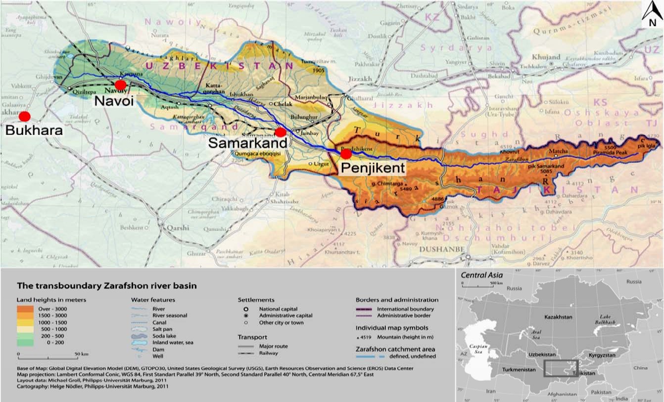
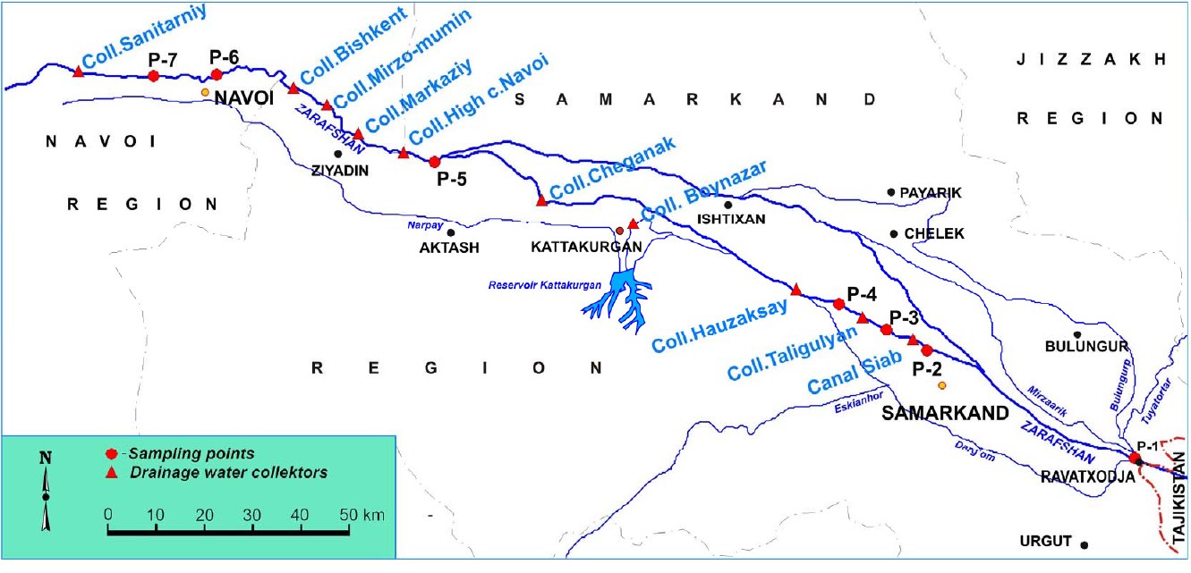
The authors compare annual mean concentrations for 2002–2009 (no data for 2007) at seven points on the Uzbek part of the Zarafshan: Ravatkhoja on the Tajik–Uzbek border (P1), three points at Samarkand near the Akdarya divider and the Siab and Taligulyan collectors (P2–P4), the settlement of Khatirchi (P5), and Navoi, 1 km above and 0.8 km below the waste-water outlet of the Navoiazot plant (P6, P7). The samples were analysed at the Hydrometeorological Research Institute (NIGMI) in Tashkent. The river, fed by glaciers and snow from the Zeravshan glacier in Tajikistan, is 781 km long, drains 143,000 km² and has a long-term mean discharge of 190 m³/s; flow peaks in July and is lowest in February–March.
Nitrate ranged from 0.52 to 3.60 mg/L and rose downstream, ammonium from 0.01 to 0.12 mg/L and iron from 0.01 to 0.15 mg/L, all below Uzbekistan’s limits. Fluorine averaged about 0.2 mg/L at Ravatkhoja and rose downstream, still below the limit of 0.75 mg/L; the authors link it to phosphate fertiliser in drainage water. Arsenic was highest at Ravatkhoja, reaching 5.5 µg/L in 2005, and zinc there reached 11 µg/L in 2003, just above the limit of 10 µg/L; the authors attribute both to ore processing in Tajikistan. Hexavalent chromium at Navoi was two to three times the limit of 0.001 mg/L in 2002–2003 and reached about 3.8 µg/L below the city; organochlorine pesticides stayed below their limits.
Collector-drainage water from irrigated land is the main source of pollution along the river. In Samarkand region 2.4–2.5 km³ of river water a year goes to irrigation, and drainage discharge was 1.23–1.50 km³ a year in 2002–2004; the large collectors there carry water of 0.74–0.76 g/L. In Navoi region drainage discharge was 0.75–0.88 km³ a year in 2002–2005; the Akaltin-2, Central and Narpay collectors bring 95.4 million m³ of water of 1.66–2.93 g/L to the river, and in 2004–2006 the collectors sampled in Navoi region carried 1.45–2.77 g/L, with 702–1,352 mg/L of sulphate and 56.5–167 mg/L of chloride, more than the river.
Figures (3)
How to cite
R. Kulmatov, C. Opp, M. Groll and D. Kulmatova (2013). Assessment of Water Quality of the Trans-Boundary Zarafshan River in the Territory of Uzbekistan. Journal of Water Resource and Protection, 5(1), 17–26. https://doi.org/10.4236/jwarp.2013.51003