Journal articleFree to read
Assessment of the Ili basin potential for underground CO2 storage
Оценка потенциала Илийского бассейна для подземного хранения СО2
- Satbayev University, Almaty, Kazakhstan
https://doi.org/10.37878/2708-0080/2026-5.02
Highlights
- Data: 2D CDP seismic profiles (reprocessed with PSDM) and 22 wells of the Zharkent depression; sedimentary cover up to 5,000 m.
- Geothermal zone from 2,800–3,600 m depth: water at 75–100 °C and more, up to 165 °C; calculated 88.6 °C and 255.7 bar at 2,600 m.
- Thermal aquifer complexes: Permian from 1,200 m; Triassic from 1,080 m (2,620–2,990 m on the Usek area).
- Jurassic sandstones: up to 70% of the section, porosity 20–26%, permeability 40–100 mD (up to 120 mD at Usek); Lower Triassic: 18–23%, 8–45 mD.
- Penjin anticline: 15 × 5 km, amplitude 600 m, 75 km²; Aydarly uplift: 6.25 km², amplitude 100 m.
- Jurassic aquifer model: 1,323,758,200 m², −1,566 to −3,700 m; effective pore volume 2,918.6 thousand m³ (mean porosity 18.5%, mean permeability 127.6 mD).
- CO2 storage capacity: 34.11 (P10), 49.52 (P50) and 110.05 (P90) thousand tonnes.
Keywords
- Zharkent Depression
- Jurassic horizon
- reservoir
- collector
- seal
- seismic exploration
- drilling
- water-bearing capacity
- carbon dioxide
Summary
S. A. Istekova, A. V. Logvinenko, D. S. Kairov, Y. N. Narimanov, N. K. Slambek and G. K. Bekbaltina of Satbayev University in Almaty assess whether the Ili sedimentary basin could store carbon dioxide from industry in Almaty and the Almaty Region, which emits more than 2 million tonnes of CO2 a year. The basin has no oil fields, so they look at deep saline aquifers. They reinterpreted 2D common-depth-point seismic profiles, reprocessed with pre-stack depth migration, together with data from the 22 wells of the Zharkent depression (18 in its west and south-west, 4 in its centre), and built structural, lithological and petrophysical models in Petrel.
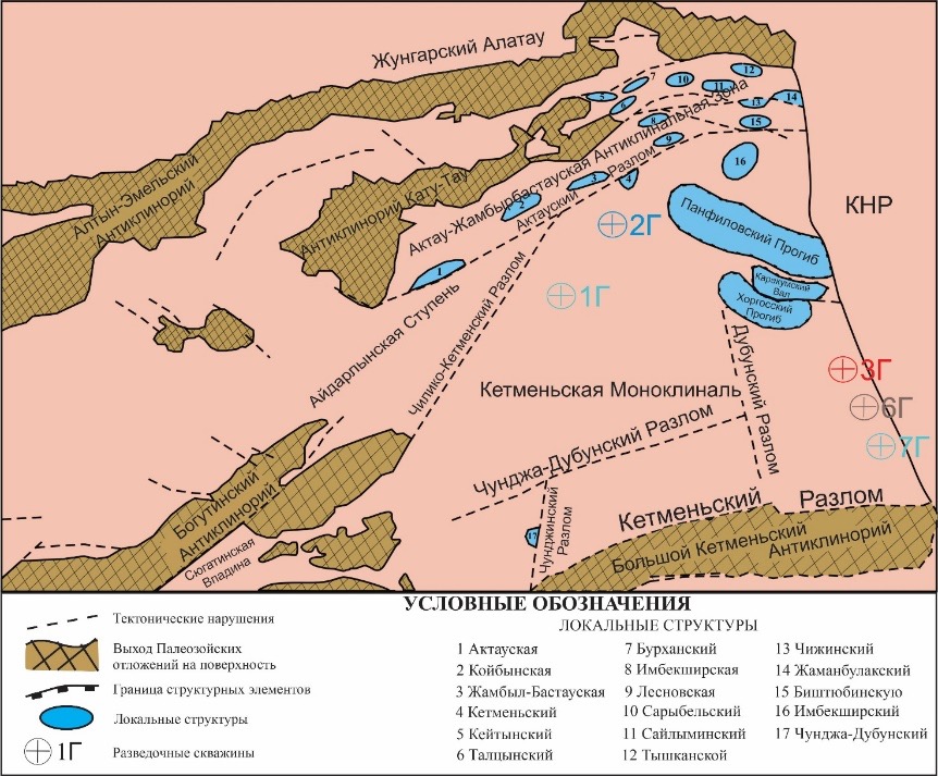
The basin has two troughs separated by the Bogutin saddle: the East Ili (Zharkent) trough in the east and the Almaty (West Ili) trough in the west. In the Almaty trough continental Neogene–Quaternary red beds lie directly on the Palaeozoic basement, so the authors rule it out for storage. The Zharkent trough holds up to 5,000 m of sediments, with up to 1,200 m of Permian, Triassic and Jurassic rocks. On the North Ketmen monocline they map three local structures: the Penjin anticline (15 × 5 km, amplitude 600 m, 75 km², running east into China), the Usek monocline and the Aydarly uplift (6.25 km², amplitude 100 m). Many faults could seal off traps.
Lower Triassic fine-grained sandstones have an open porosity of 18–23% and a permeability of 8–45 mD. Sandstones make up to 70% of the Jurassic, with a porosity of 20–26% and a permeability of 40–100 mD (up to 120 mD on the Usek area); Cretaceous sandstones reach 20–30% porosity and Pliocene sandstones 10–22%. Lacustrine clays of the Upper Jurassic Kairgaly Formation and the Upper Cretaceous–Palaeogene clays are the regional seals.
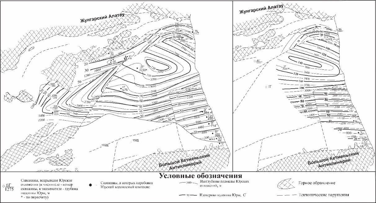
The Zharkent artesian basin is fed from the surrounding ranges, which rise to 3,500 m and carry glaciers. It has seven aquifer complexes, from Permian to Quaternary. The Permian (from 1,200 m) and Triassic (from 1,080 m; 2,620–2,990 m on the Usek area) complexes hold thermal water. Cretaceous horizons met at 782 and 2,290 m hold ultra-fresh water, including calcium chloride water in well 2T, and the mineralisation of the Palaeogene–Neogene complex (50–2,600 m) rises from south to north-west. The waters of the depression are thermal: the geothermal zone, with water at 75–100 °C and more (up to 165 °C), begins at 2,800–3,600 m, deeper in the south than in the centre. Fresh artesian water drains the southern part, while thrusts cut the northern zone off from recharge. The groundwater is of the calcium chloride and sodium bicarbonate types, with iodine, bromine and boron.
The model of the Jurassic aquifer covers 1,323,758,200 m² at depths of −1,566 to −3,700 m. Reservoir rock makes up 48.3–48.5% of it, giving an effective reservoir volume of 15,776.1 thousand m³ and, at a mean porosity of 18.5% (12–22.5%), an effective pore volume of 2,918.6 thousand m³; core permeability is 3.3–300.2 mD (mean 127.6 mD). At 2,600 m the authors calculate a pressure of 255.7 bar and a temperature of 88.6 °C, above the critical point of CO2, which gives a density of 628.4 kg/m³. With the IEAGHG method the storage capacity comes to 34.11, 49.52 and 110.05 thousand tonnes of CO2 (P10, P50 and P90). The authors call this a preliminary estimate and ask for 3D seismic, exploration drilling with coring and numerical flow modelling. The basin's thermal waters are also the subject of Kismelyeva et al. for the Zharkunak zone and Kalitova et al. for the western Almaty sector.
Figures (2)
How to cite
S. A. Istekova, A. V. Logvinenko, D. S. Kairov, Y. N. Narimanov, N. K. Slambek and G. K. Bekbaltina (2026). Assessment of the Ili basin potential for underground CO2 storage. Neft i Gaz, No. 5 (155), 2026, pp. 30–48. https://doi.org/10.37878/2708-0080/2026-5.02