Journal articleOpen access
Ecological monitoring of groundwater of the Karauzyak district
Экологический мониторинг грунтовых вод Караузякского района
- Department of Chemistry, Ajiniyaz Nukus State Pedagogical Institute, Nukus, Uzbekistan
- Department of Physical Geography and Hydrometeorology, Berdakh Karakalpak State University, Nukus, Uzbekistan
Highlights
- 20 wells sampled in Karauzyak district in 2024–2025 (Table 1).
- Table 1 (units not given): dry residue 1,010–4,800; sulphate 220.8–936.0; fluoride 0.18–1.56.
- Upper Cretaceous (K2) aquifer of the South Aral artesian basin: 1.4–62.5 g/L, opened at 300–700 m.
- Aquifer water in Karauzyak district: 3.4–10.2 g/L, chloride–sodium; pH 7.10–8.30; total hardness 6.5–26.5 mg-eq/L.
- Heads at the ground surface or 0.5–4.5 m below it; well 46 flowing at 6.0 L/s; pumped yields 0.2–13.3 L/s at drawdowns of 10.4–11.8 m.
- Hydraulic conductivity 0.12–7.47 m/day (mean 0.64 m/day).
- Mineralisation in 2025: Senonian 1.8–2.4 g/L, Turonian 3.5–4.0 g/L, Cenomanian 1.8–2.4 g/L; Albian 12.8–16.3 to 24.2–45 g/L.
- Upper Cretaceous water at 470–490 m: possible use for irrigation; for drinking only after desalination.
Abstract
This article summarizes the results of hydrogeological surveys conducted in the Karauzak district of the Republic of Karakalpakstan in 2025. During the study of the physicochemical indicators of water from wells in the Karauzyak district, it was established that in all water samples, the average temperature of the studied water did not exceed 5°C and had a neutral environment. In terms of organoleptic properties, all the studied waters were transparent, colorless, and odorless. The water samples being studied belong to soft waters with neutral pH values. Among the cations, sodium and potassium ions predominated, reaching 140 mg/l. The concentrations of calcium and magnesium reached 98.2 and 96.9 mg/l, respectively. The total iron content in the water samples ranged from 0.23 to 0.29 mg/l. In all the studied waters, the predominant anion is the sulfate ion, the content of which reached 230 mg/l. The studied water parameters did not exceed the maximum permissible concentrations according to the Sanitary Regulations (SanPiN) in force in Uzbekistan, which demonstrates the suitability of the studied groundwater for drinking.
English abstract from the paper. The authors’ abstract, reproduced under CC BY 4.0.
Keywords
- groundwater
- geological and hydrogeological conditions
- physicochemical parameters
- chemical analysis
- anionic and cationic composition
- wells
- groundwater monitoring
- artesian basin
- mineralization
- aquifers
- ecology
In plain English
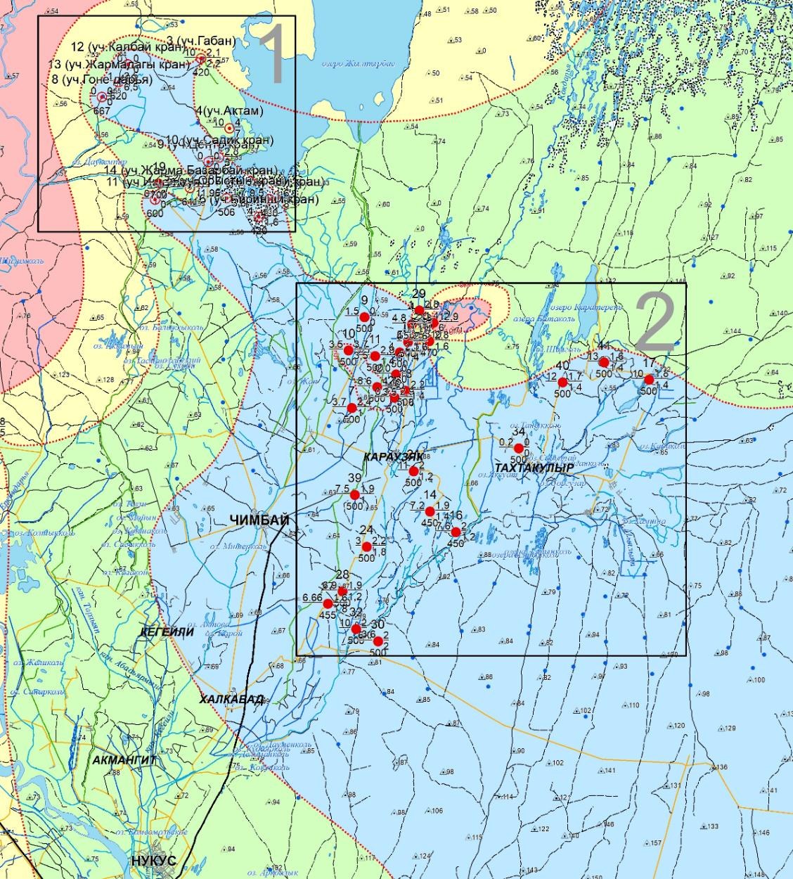
Karauzyak district lies in the north of Karakalpakstan, on the right bank of the Amu Darya, among irrigated land in desert conditions. Groundwater there is rising at one of the fastest rates in Karakalpakstan, fed by leakage from canals such as Tash-arna and Kok-ozek and by poor drainage, and causes secondary salinisation of soils; in some villages up to 70% of residents depend on groundwater. In 2024 and 2025 the authors made two field trips to sample thermal and shallow groundwater and took water from 20 wells along several hydrogeological profiles (Fig. 1). The samples were analysed at the Central Chemical and Bacteriological Laboratory of Karakalpak suv ta’minot JSC.
For the 20 wells, named after villages, farms or well numbers, the analyses cover odour, taste, colour, turbidity, ammonium, nitrite, nitrate, oxidisability, sulphate, dry residue, iron, copper, aluminium, fluoride, lead, manganese and zinc, with two bacteriological counts (Table 1, no units given). Dry residue ranges from 1,010 to 4,800 and sulphate from 220.8 to 936.0; fluoride is 0.18–1.56, nitrate 0–7.04 and total iron 0–0.12, and aluminium and lead were not detected. The authors conclude that the water does not exceed the maximum permissible concentrations of Uzbekistan’s sanitary rules (SanPiN) and is fit for drinking.
Groundwater of the Upper Cretaceous (K2) deposits of the South Aral artesian basin, held in clayey sandstones, has a mineralisation of 1.4–62.5 g/L, and in the areas studied the aquifer was opened at depths of 300–700 m. In Karauzyak district the water in the samples holds 3.4–10.2 g/L and is of chloride–sodium type; the authors explain these comparatively low values by discontinuous confining beds and ‘filtration windows’ through which fresher Upper Cretaceous water mixes with saline Lower Cretaceous water. pH is 7.10–8.30, oxidisability 2.15–5.85 and total hardness 6.5–26.5 mg-eq/L. Heads stand at the ground surface or 0.5–4.5 m below it; only well 46 flowed on its own, at 6.0 L/s. Pumped yields were 0.2–13.3 L/s at drawdowns of 10.4–11.8 m, and hydraulic conductivity is 0.12–7.47 m/day, 0.64 m/day on average. Because of the high mineralisation and low heads, the authors do not recommend these aquifers for irrigation.
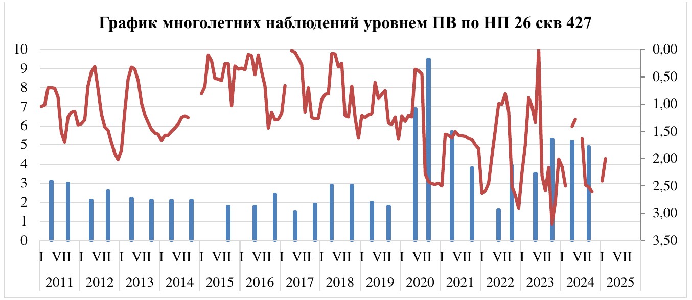
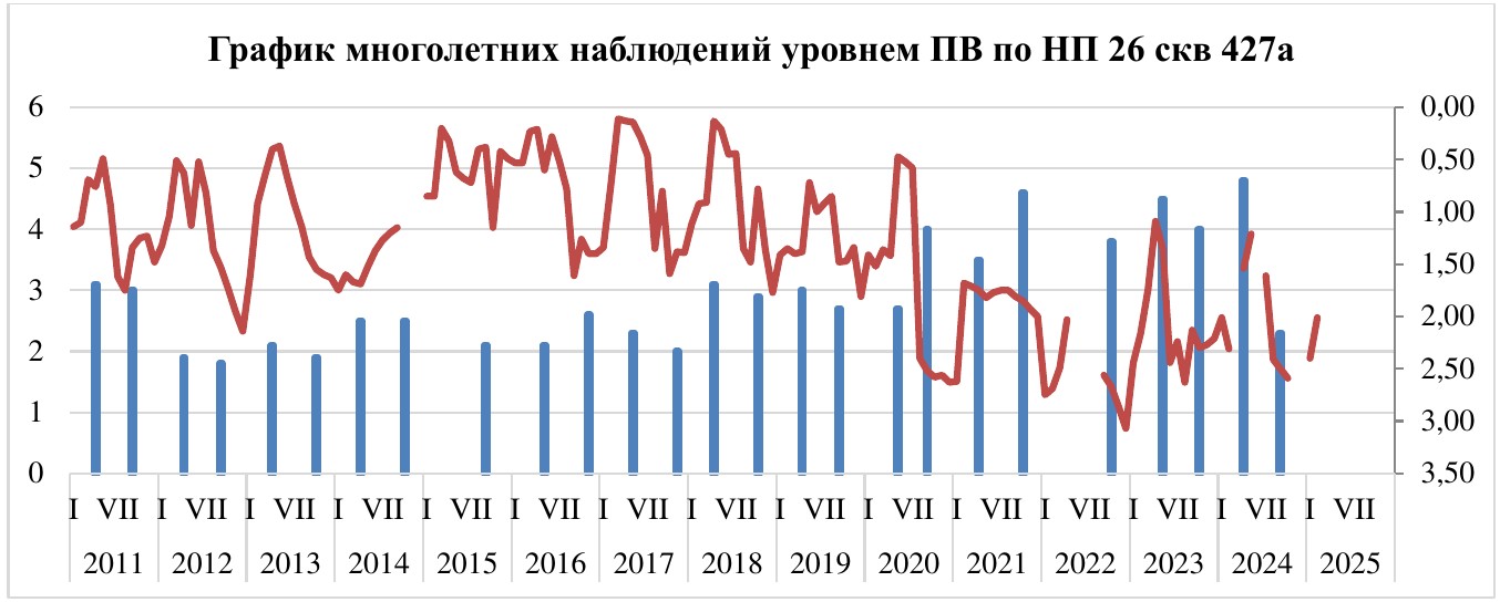
In 2025 the mineralisation of the district’s aquifers stayed stable: 1.8–2.4 g/L in the Senonian, 3.5–4.0 g/L in the Turonian and 1.8–2.4 g/L in the Cenomanian horizon. Water of the Albian horizon is more mineralised, from 12.8–16.3 to 24.2–45 g/L, and is described as highly thermal. These wells lie within a single cone of depression at an absolute level of 65–60 m, inside which the Senonian and Turonian horizons in places no longer flow. The dry residue mostly (in 27 of 29 wells) did not exceed 1.6–3.8 g/L; in wells 12 and 31 it reached 8.4–9.2 g/L, of sulphate–chloride sodium type. Upper Cretaceous water from 470–490 m could be used for irrigation, but for drinking only after desalination. Groundwater levels at observation point 26 (wells 427 and 427a) are plotted for 2011–2025 (Figs. 3 and 4). Water from two wells in Khojeli and Nukus districts held 1,344 and 1,728 mg/dm³ of dry residue.
Figures (3)
How to cite
A. O. Asamatdinov and K. M. Dzhaksymuratov (2026). Ecological monitoring of groundwater of the Karauzyak district. Universum: tekhnicheskie nauki (Universum: Technical Sciences), 2026, No. 3 (144), pp. 8–14. https://7universum.com/ru/tech/archive/item/22233