Journal articleFree to read
Geothermal models of deep heat and mass transfer channels in the western part of the Bukhara–Khiva palaeorift
Геотермические модели каналов глубинного тепломассопереноса в западной части Бухаро-Хивинского палеорифта
- Institute of Geology and Exploration of Oil and Gas Fields (IGIRNIGM), Uzbekistan
Highlights
- Field geothermal survey, 2003–2004: temperature at 2 m depth along three profiles, 278 km in total.
- Temperature at 2 m: 12–23 °C, mean 17.7 °C, standard deviation 1 °C, accuracy 0.03 °C.
- Regional background heat flow 69 mW/m², of which 30 mW/m² from the mantle; radiogenic part 28–37 mW/m².
- Relation used: T = 0.04q + 14, or q = 25(T − 14); map refined to 1:200,000.
- 9 positive and 2 negative anomalies; positive up to 140 mW/m², negative about 40 mW/m²; Tegermen up to 120 mW/m².
- Isotherms: 100 °C at 3–4 km, 200 °C at 7–9.7 km, 400 °C at 15–25 km, 600 °C at 24–40 km.
- Channel width 400–2,000 m (mean 730 m); initial fluid temperature 750–800 °C.
Keywords
- heat flow
- field geothermal survey
- isotherms
- Bukhara–Khiva palaeorift
- deep heat and mass transfer
- Tegermen
Summary
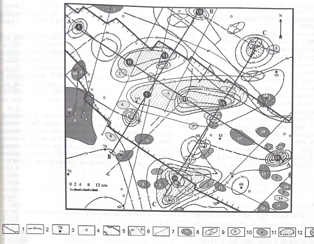
In 2003–2004 the Institute of Geology and Exploration of Oil and Gas Fields (IGIRNIGM) and Uzbekgeofizika made the first field geothermal survey in Uzbekistan, in the western part of the Bukhara–Khiva palaeorift, to map active channels of deep heat and mass transfer hidden under the sedimentary cover. Temperature was measured at 2 m depth along three reference geotraverses, 278 km in total, which had also been surveyed by magnetotelluric sounding and high-precision gravimetry. The temperatures, measured to 0.03 °C and reduced to 10:00 on 15 May 2003, ranged from 12 to 23 °C, with a mean of 17.7 °C and a standard deviation of 1 °C.
Crustal models along the profiles give a regional background heat flow of 69 mW/m² in the Bukhara–Khiva oil and gas region, of which 30 mW/m² comes from the mantle; the radiogenic part is 28–37 mW/m². From the measurements the authors derive a linear relation between heat flow and temperature at 2 m depth, T = 0.04q + 14 (q = 25(T − 14)), and use it to refine the heat-flow map of the western Bukhara–Khiva region to 1:200,000. The survey found 9 positive and 2 negative anomalies that exceed the standard deviation by 0.3–4.5 °C. It confirmed the Tegermen anomaly (up to 120 mW/m², 3.5 °C above the mean at 2 m) and the South Guzhayli anomaly, and found new ones along deep faults.
Heat flow over the palaeorift is raised to 80 mW/m² and more, which the authors attribute to uplifted mantle rocks with 30% higher thermal conductivity than the crust. Positive anomalies reach 140 mW/m²; two negative ones fall to about 40 mW/m², which the authors explain by groundwater flowing downward and cooling the rocks. The 100 °C isotherm lies at 3–4 km, 200 °C at 7–9.7 km, 400 °C at 15–25 km and 600 °C at 24–40 km. Modelling gives channel widths of 400–2,000 m (730 m on average) and initial fluid temperatures of 750–800 °C; the channels have been active for tens of thousands of years at Beshtepa and West Kokchi and for about a million years at Urtabulak and Gazli. The map names nine channels, Tashkuduk, Guzhayli, West Beshtepa, West Kokchi, South Guzhayli, Muradkuduk, Atbakar, Tegermen and Beshtepa, the same nine shown on the 2007 heat-flow map reprinted in a 2025 review of natural hydrogen.
Figures (1)
How to cite
A. A. Abidov, A. A. Polikarpov and U. N. Rakhmatov (2005). Geothermal models of deep heat and mass transfer channels in the western part of the Bukhara–Khiva palaeorift. O‘zbekiston neft va gaz jurnali (Uzbek Journal of Oil and Gas), No. 2, 2005, pp. 15–18. https://drive.google.com/file/d/1XHFnuOXt547SJacbXrHvu3thea21EUaJ/view