Journal articleFree to read
Forecast of the oil and gas prospects of the Jurassic deposits of the Bukhara-Khiva region by the hydrodynamic method
Прогноз перспективы нефтегазоносности юрских отложений Бухаро-Хивинского региона гидродинамическим методом
- Institute of Geology and Exploration of Oil and Gas Fields (IGIRNIGM), Tashkent, Uzbekistan
- University of Geological Sciences, Tashkent, Uzbekistan
Highlights
- Lower–Middle Jurassic reduced heads: 2,322–2,747 m (east Beshkent trough) to 199–343 m (Karim, Rasylkuduk and others).
- Beshkent trough: permeability 0.0001 darcy, porosity 4%; in anomalous zones hydraulic gradient 21.8–42.8 m/km and filtration velocity 1.4–3.6 cm/year.
- East flank of the Dengizkul uplift: permeability 0.0001–0.0008 darcy, porosity 6–7%, hydraulic gradient 7.4–58 m/km.
- Abnormally high pressure in 16 of 42 measurements (coefficient above 1.20).
- Anomaly coefficients: Chilgumbaz 1.92, Beshkent 1.74, Kamashi 1.73, Nishan 1.55, Chulkuvar 1.49, Feruza 1.44, Izgancha 1.43, Jambulak 1.36, Sherkent 1.31, Mangit 1.31.
- Upper Jurassic heads fall from 1,096 m (Karail) to 800–900 m (Buzakhur) along the Lyangar–Karail fault.
Keywords
- pressure head
- hydrodynamics
- formation water
- abnormally high pressure
- Jurassic
- Bukhara–Khiva region
- Beshkent trough
Summary
Written for oil and gas exploration, the paper maps reduced pressure heads in the Jurassic water-pressure complex of the Bukhara–Khiva region, the north-eastern part of the Amu Darya syneclise, with the methods of Silin-Bekchurin and Hubbert, and calculates hydraulic gradients, filtration velocities and a coefficient of hindered water movement for pairs of areas.
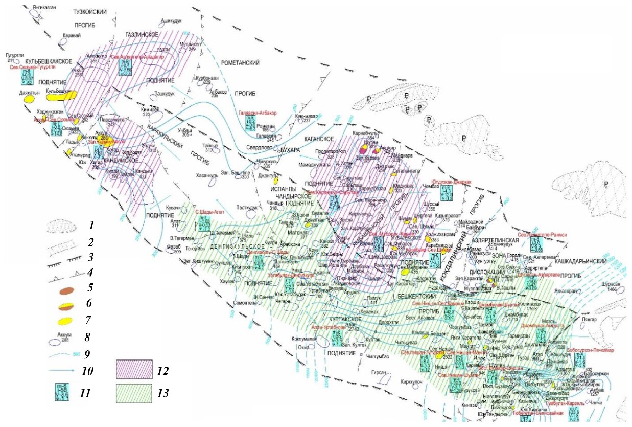
In the Lower–Middle Jurassic, the highest heads, 2,322–2,747 m, are in the east of the Beshkent trough around North Nishan, Girsan, Chilkuvar and Alan, and the lowest, 199–343 m, around Karim, Rasylkuduk, Jarkak, West Karaiz, Sarytash, Khodji, Khatar and Kumli. Heads drop from Alan (2,747 m) to North Urtabulak and Pamuk (709 and 431 m), which the authors read as an elision (compaction-driven) water-pressure system. Mean permeability and porosity in the Beshkent trough are 0.0001 darcy and 4%.
In both the Lower–Middle and Upper Jurassic, formation water flows from the south and south-east to the north and north-west. In the Jurassic of the Beshkent trough, 16 of 42 pressure measurements show abnormally high pressure, with anomaly coefficients above 1.20, mostly under thick Upper Jurassic salt; the authors suggest that Jurassic fluids rise into the Cretaceous near Buzakhur and North Guzar.
Figures (1)
How to cite
T. Kh. Shoimurotov, K. B. Yusupov and S. T. Rakhmanova (2024). Forecast of the oil and gas prospects of the Jurassic deposits of the Bukhara-Khiva region by the hydrodynamic method. Geologiya fanlari universiteti xabarlari (Bulletin of the University of Geological Sciences), No. 2, 2024, pp. 5–18. https://files.uzgeouniver.uz/media/files/%D0%92%D0%B5%D1%81%D1%82%D0%BD%D0%B8%D0%BA_2_2024.pdf