Journal articleOpen access
MODFLOW Application for Exploitable Groundwater Resource Assessment of the Zhem Artesian Basin Aquifer Complex, Kazakhstan
- Institute of Hydrogeology and Geoecology named after U. M. Ahmedsafin, Satbayev University, Almaty, Kazakhstan
- Department of Water, Oil and Gas Resources and Geo-Risks, Kyrgyz State Technical University named after I. Razzakov, Bishkek, Kyrgyzstan
- Department of Chemical Engineering, Ariel University, Ariel, Israel
- Department of Environmental Research, Eastern R&D Center, Ariel, Israel
- Renewable Energy and Energy Efficiency Group, Department of Infrastructure Engineering, Melbourne School of Engineering, The University of Melbourne, Melbourne, Australia
https://doi.org/10.3390/app15105443
Highlights
- Basin area 104,000 km²; model area 163,200 km² in 5 × 5 km cells.
- Albian–Cenomanian complex: 25–980 m thick (147 m on average); heads 4–383 m (49 m on average); filtration coefficient 0.8–29.8 m/day; well yields 6 to 40–63 L/s; salinity 0.2–5.3 g/L.
- Pumping tests: hydraulic conductivity 0.8–14.1 m/day (5.6 on average, 74 sites); transmissivity 111–1,070 m²/day (490 on average); specific yield 0.01–0.2 (0.13 on average).
- Water samples by salinity: 37 (69%) under 1 g/L, 7 (13%) 1–3 g/L, 10 (18%) 3–10 g/L.
- Operational reserves 755 thousand m³/day (131 deposits and sites); approved exploitable resources 173,000 m³/day; modelled long-term resources 629,400 m³/day.
- Drawdown cones up to 50–80 m; river flow reduced by about 110 thousand m³/day (about 6%).
Abstract
Groundwater resources are becoming increasingly scarce, especially in arid regions of western Kazakhstan. By 2070, the domestic and drinking water demands will increase from 640 to 901 thousand m3/day. This deficiency may be overcome by utilizing the Zhem Artesian Basin’s Cretaceous Albian–Cenomanian aquifer complex. The hydrodynamic interactions between the 123 known aquifer segments and recharge zones of these promising, exploitable, high-quality groundwater sources are unclear. While MODFLOW is a nominal platform for groundwater flow assessment, which is usually used for the simulation of simple hydrological scenarios, in this study, integrating several different scales and functional modules over a GIS platform enabled delineation and the forecast of this multi-layer aquifer complex. The MODFLOW simulation assessed exploitable groundwater resources and reservoir interactions, enabling the establishment of a simultaneous operation to the Zhem aquifer complex and its neighboring reservoirs. The model suggests that the total exploitable groundwater resources may grow to 629.4 thousand m3/day during the next 50 years. The simultaneous drawdown model suggests a water level decrease of up to 80 m at the end of this period, which will cause a river flow reduction of approximately 6% of the average long-term river flow. Thus, the assessed exploitable groundwater resources will cover more than 70% of the future regional water demand. The mathematical model developed may be used for monitoring and forecasting groundwater head and water balance changes and may be applied to attain a more detailed groundwater resource transfer scheme with economic criteria.
English abstract from the paper. The authors’ abstract, reproduced under CC BY 4.0.
Keywords
- exploitable groundwater resources
- numerical modeling
- Zhem Artesian Basin
- groundwater withdrawal
- permissible head drawdown
- MODFLOW model
In plain English
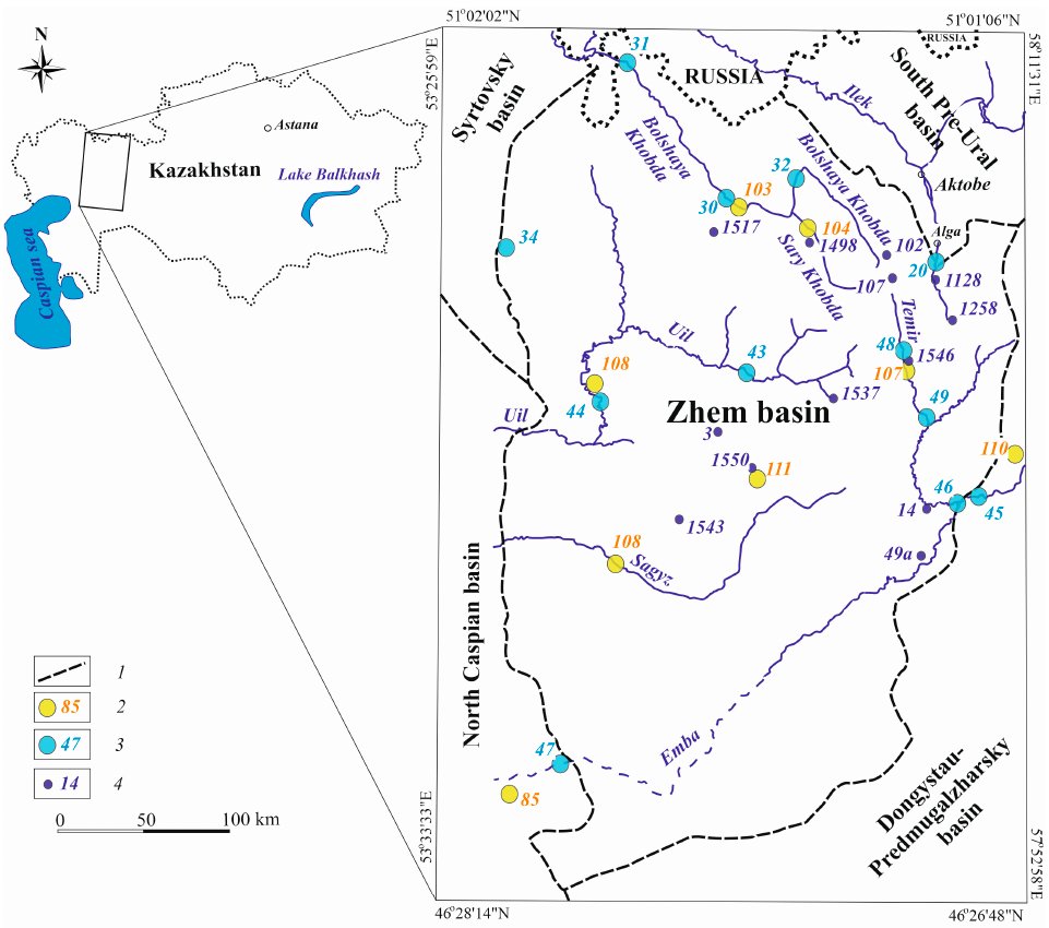
Daniyar S. Sapargaliyev, Yermek Zh. Murtazin and Vladimir A. Smolyar of the U. M. Ahmedsafin Institute of Hydrogeology and Geoecology at Satbayev University, with Vladimir Mirlas and Yaakov Anker of Ariel University, model the groundwater of the Zhem Artesian Basin in western Kazakhstan. The basin lies in the eastern part of the Caspian depression and covers 104,000 km², 82% of it in Aktobe region. The Pre-Palaeozoic folded basement lies 5–12 km deep. The Kazakh groundwater cadastre lists 131 explored groundwater deposits and sites in the basin, with operational reserves of 755 thousand m³/day, mostly in Albian–Cenomanian strata. Of these reserves, 79% are fresh, with mineralisation of up to 1 g/L, and 14% have 1–3 g/L.
The Lower Cretaceous–Cenomanian aquifer complex (K1–K2s) is the most widespread and promising. Its water-bearing sediments are 25–980 m thick, 147 m on average, and its groundwater heads are 4–383 m, 49 m on average. Filtration coefficients are 0.8–29.8 m/day and well yields 6 to 40–63 L/s. Total salinity is 0.2–5.3 g/L and rises from north-east to south-west, the direction of flow. Fresh water in the north-east, at Kundaktakyrskoye, Kandagachskoye, Sarybulakskoye and other deposits, is bicarbonate–calcium–magnesium water; to the south-west it turns into chloride–sulphate and sulphate–chloride–bicarbonate sodium and sodium–calcium water. Below lies the Lower Cretaceous Aptian–Neocomian complex (K1), 30–100 m thick, at depths of 90–1,100 m.
The MODFLOW model covers 163,200 km² on a grid of 5 × 5 km cells, with river, constant-head, recharge and evapotranspiration boundary conditions. Hydraulic parameters come from pumping tests at 88 sites, and withdrawals in 2007–2022 were entered for the Emba, Kenkiyak, Kandagach, Alga, Shubarkuduk and other areas. Hydraulic conductivity averages 5.6 m/day (0.8–14.1), transmissivity 490 m²/day (111–1,070) and specific yield 0.13.
Forecasts for 25 and 50 years put the basin’s long-term exploitable groundwater resources at 629,400 m³/day, against approved resources of 173,000 m³/day in 123 aquifer segments and wellfields. Pumping all approved resources at once would create drawdown cones up to 50–80 m deep and reduce river flow by about 110 thousand m³/day, about 6% of the long-term mean. At Kenkiyak, Kandagach, Zharkamys and Dzhurun, drawdowns could exceed permissible values, which cuts their potential from 122,560 to 37,000 m³/day. The authors conclude that the 630,000 m³/day of drinking-quality groundwater could meet more than 70% of the future demand of the Aktobe, Atyrau and Mangistau regions, which grows from 640 to 901 thousand m³/day by 2070.
Figures (1)
How to cite
Daniyar Serikovich Sapargaliyev, Yermek Zhamshitovich Murtazin, Vladimir Mirlas, Vladimir Alexandrovich Smolyar and Yaakov Anker (2025). MODFLOW Application for Exploitable Groundwater Resource Assessment of the Zhem Artesian Basin Aquifer Complex, Kazakhstan. Applied Sciences, vol. 15, no. 10, 5443. https://doi.org/10.3390/app15105443